Department of Santa Barbara
Santa Bárbara is one of the eighteen departments that make up the Republic of Honduras.

General Information
The department of Santa Bárbara was one of the seven departments originally created by the first chief of state of Honduras, Licentiate Don Dionisio de Herrera on June 28, 1825.
Later, under President Domingo Vásquez, the department was divided, and the department of Cortés was created on July 4, 1893.
It borders the Republic of Guatemala to the north, the departments of Lempira, Intibucá, and Comayagua to the south, and again Guatemala and Copán to the west, divided by the Sierra del Espíritu Santo. This department stands out for its people with colored eyes and white skin, as its inhabitants are descendants of Spaniards who lived in the area. Origin of its name: In honor of the Virgin of Santa Bárbara, who has always been venerated and was brought by the Spaniards.
Important Facts about Santa Bárbara
- Departmental capital: Santa Bárbara
- Land area: 5025 km2
- Administrative Code: 16
- Population: 416448 inhabitants (2012)
- Population density: 83 hab/km2
- Date of creation: June 28, 1825.
History of Santa Bárbara
The first inhabitants of what is now the department of Santa Bárbara are of Lenca and Maya origin, as evidenced by archaeological investigations. According to Spanish chroniclers, at the time of discovery, its inhabitants were located between the provinces of Naco and Cerquín.
In the 1582 report by the governor of Comayagua, Alonso de Contreras Guevara, the indigenous town of Tencoa was entrusted to King Philip II with forty tributaries in the jurisdiction of the Spanish city of Gracias a Dios. In the list of towns in the province of Comayagua in 1684, it appears as the district of Tencoa.
In the ecclesiastical registry conducted in 1791 by Bishop Fernando Cadiñanos, it appears as the curacy of Tencoa, being the head of it. In the 1804 report by governor intendente Don Ramón de Anguiano, it appears as the sub-delegation of Tencoa, whose main town was Santa Bárbara.
The Constituent Assembly of Honduras decreed on June 28, 1825, the first territorial division of the country. The new department of Santa Bárbara was made up of the party of the same name with the parishes of Santa Bárbara and Celilac; and the party of San Pedro with San Pedro, Yojoa, Quimistán, and Omoa.
Geography of Santa Bárbara
It is located in the northwestern part of the country.
This department, which has about 312 villages and more than 1000 hamlets, is located in the northwestern part of Honduras.
Boundaries
- North: Department of Cortés and the Republic of Guatemala;
- South: Departments of Lempira and Intibucá;
- East: Departments of Cortés and Comayagua;
- West: Department of Copán.
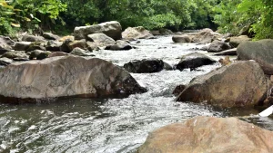
Rivers: Chamelecón, Ulúa, Palaja, Jicatuyo, Macholoa, and Cancique. Protected Areas: National Parks, Santa Bárbara and Cusuco mountains; multiple-use reserve, Lake Yojoa. Mountain Ranges: Espíritu Santo, Gallinero, and Atima. Mountains: Santa Bárbara or Moroncho, Chimizales, Quezapaya, de los Monos, Joconal, and Poza Azul.
Fauna and Flora of Santa Bárbara
Mammals: Shrew, squirrel, coati, armadillo, skunk, raccoon, deer, pacas, wild boar, spider monkey, howler monkey, tapir, coyote, fox, wild cat, puma, ocelot, and jaguar. Birdlife: Woodpecker, turkey, dove, roadrunner or dog’s soul, magpie, grackle, quail, pigeon, parakeet, motmot or guardabarranco, mockingbird, goldfinch, thrush, hawk, vulture, owl, and osprey. Flora: Forests
Municipalities of Santa Bárbara
See List of Municipalities of Honduras
- Santa Bárbara 1601
- Arada 1602
- Atima 1603
- Azacualpa 1604
- Ceguaca 1605
- San José de las Colinas 1606
- Concepción del Norte 1607
- Concepción del Sur 1608
- Chinda 1609
- El Níspero 1610
- Gualala 1611
- Ilama 1612
- Macuelizo 1613
- Naranjito 1614
- Nuevo Celilac 1615
- Petoa 1616
- Protección 1617
- Quimistán 1618
- San Francisco de Ojuera 1619
- San Luis 1620
- San Marcos 1621
- San Nicolás 1622
- San Pedro Zacapa 1623
- Santa Rita 1624
- San Vicente Centenario 1625
- Trinidad 1626
- Las Vegas 1627
- Nueva Frontera 1628
Economy of Santa Bárbara
Most of the land is dedicated to agriculture, livestock, and coffee. The craft industry includes the production of reed hats, palm mats, cordage, pottery, among others.
Mining is also present with the largest underground deposit in Central America, such as the El Mochito mine. Maquilas: Green Valley Industrial Park, Quimistán, and Santa Bárbara. Production: Cultivation of coffee, banana, plantain, sugarcane, orange, tobacco, corn, beans, sorghum, and soybeans; raising of cattle, horses, pigs, and goats; poultry farming; industry: reed hats, pottery, palm and cordage. Commerce: Santa Bárbara, Trinidad, Colinas, Quimistán, and Las Vegas. Mining: Gold, silver, copper, lead, zinc, and antimony (El Mochito mines).
Tourism in Santa Bárbara
- Archaeological sites and colonial historic centers in some municipalities,
- Lake Yojoa
- El Mochito Mine.