Municipality of San Francisco de Ojuera
San Francisco de Ojuera is a municipality in the department of Santa Bárbara in Honduras.
In the population count of 1791, it appears as the town of Ojuera, forming part of the curate of Tencoa. It is believed that it was granted municipality status in 1895, as in the Political Territorial Division of 1896, it was a municipality of the Santa Bárbara District.
Geography
Its municipal seat bears the same name. It is located between the municipalities of Concepción del Sur (north). It borders the department of Intibuca to the south, the municipality of San Pedro Zacapa to the east, and the department of Lempira and the municipalities of Ceguaca and Santa Rita to the west.
Villages
- San Francisco de Ojuera
- El Diviso
- El Gavilán
- El Pilón
- La Chorrera
- La Palca
- La Vega
- Plan de Los Cedros
- Pueblo Nuevo
- San Isidro
- San Ramón
- Santa Ana
- Santa Fe
- Bordo Villanueva
- La Leona
- San Rafael del Pito
- Piedra de Agua
- La Leonera
- Plan de Encima
- La Venada
- La Estancia
- San Antonio de Romero
- El Copinol
- El Aguacatal
The most well-known villages are La Vega, La Palca, and Santa Fe, being these villages the main sources of income, as the majority of the population is located in them. They dedicate their main activity to small-scale cultivation of coffee, corn, beans, vegetables, and cocoa, among others.
Tourist attractions
- Las Cuevas de Malera, en La Vega
- Montaña Verde, área protegida, en La Vega
- Aguas termales Gualcarque
- Antiguas ruinas del pueblo, vestigios datan de 1650
- Primer casa del pueblo frente al parque central, en San Francisco
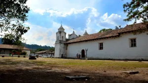
- Iglesia católica que data del año 1748, en San Francisco
- Puente de Molo que data del año 1800
- Puente del diablo en El Pilón
- Los Lajones, en La Vega
- Catarata de La Chorrera, en La Chorrera
- Pequeña Catarata La Chorrerita, en La Vega
- Rio winse
- Rio Gualcarque