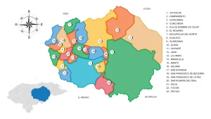
Municipality of Iriona
The municipality of Iriona belongs to the department of Colon.
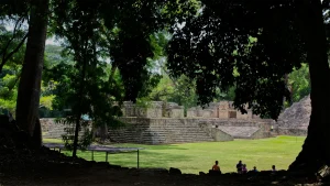
It was established as a municipality in 1892. Originally, it was a village of Trujillo and was known as Iriona Viejo. It was relocated to the Buchard port in 1895, and by 1896, it belonged to the La Mosquitia department.
General Information of Iriona
Origin of its name: Zambo name: «iri» means thorn and «ona» means one; its translation to Spanish is «a thorn.»
- Territorial area: 3986.87 km2
- Population: 22,911 inhabitants (2012)
- Date of creation: 1892
- Patronal festival: May 8-23, the feast day of St. Isidore
- Villages and hamlets: 10 villages and 57 hamlets
- Altitude: 2 meters above sea level
Principal economic activity
Cultivation of banana, citrus fruits, African palm, coffee, fruits, watermelon, mangoes, basic grains, and vegetables; breeding of cattle, pigs, and horses; rabbit farming and poultry farming.
Infrastructure
- Health: 4 CESAR (Health Centers), 2 CESAMO (Departmental Hospitals), and 1 CMI (Integrated Health Center).
Location
It is located in the coastal plain of the Caribbean in the basin of the Sico or Tinto Negro River. It is the easternmost municipality in the department of Colón.
Limits
- North: Caribbean Sea
- South: Municipality of Dulce Nombre de Culmí (Olancho)
- East: Municipalities of Brus Laguna, San Francisco Bulnes, and Wampusirpi (all in Gracias a Dios)
- West: Municipalities of Limón, Bonito Oriental, and San Esteban (Olancho)