Municipality of La Masica
The municipality of La Masica belongs to the department of Atlántida.
Since 1885, it represented a village within the municipality of San Francisco. Due to population growth and its economic importance, on November 13, 1922, it was granted municipal status during the administration of Rafael López Gutiérrez.
General Information of La Masica
Origin of its name: Masica, a name given due to the abundance of a tree with the same name, whose fruit is edible but tasteless.
- Territorial Area: 470.97 km2
- Population: 28,770 inhabitants (2012)
- Date of Creation: November 13, 1922
- Patron Saint Fair: August 30, on the day of Santa Rosa de Lima
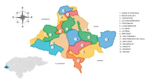
- Villages and Hamlets: 17 villages and 81 hamlets
- Altitude: 20 meters above sea level
Main Economic Activity
Cultivation of African palm, banana, citrus fruits, coconut, sugarcane, coffee, tomato, watermelon, pumpkin, and squash; raising of livestock (sheep, cattle, pigs, horses, and goats); poultry farming.
Infrastructure:
- Health: 5 CESAR (Rural Health Centers) and 2 CESAMO (Departmental Hospitals)
- Education: 3 community centers for preschool education, 3 centers for basic education, 15 centers for in-person secondary education, 59 primary education centers, and 38 kindergartens
- Transportation: railway, buses
- Communication Network: telephone, fax, telegraph, postal services, and paved access roads
Location
It is located in the Caribbean coastal plain, and the town is crossed by the Cuero River.
Limits
- North: Caribbean Sea
- South: Municipalities of Yoro and Olanchito (both in Yoro)
- East: Municipality of San Francisco
- West: Municipality of Esparta