Celaque National Park
The Parque Nacional Celaque is just 7.5 km from the colonial city of Gracias. Many years ago in the year 1537, the last indigenous resistance struggle against Spanish rule took place in this area, led by the chief Lenca “Lempira“.
Later in 1544, the city of Gracias was declared by the Spanish as the new headquarters of the “Audiencia de Los Confines” or capital of the Captaincy General of Guatemala.
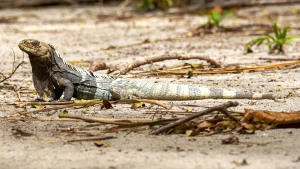
Celaque was declared a National Park in 1987 by Decree No: 87-87. The Park covers 267 km2, with 159 km2 in the core area. The Park presents an abundant pine forest, here you can find six of the seven species of pine forest that have been found in Honduras.
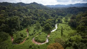
Above 1,500 meters the forest changes to a mixture of pine forest and cloud forest, including sweetgum (Liquidgum styraciflua), Mountain Zapotillo (Clethra Macrophylla) and Aquacatillo (Nectandra gentlei) Between 1,800 and 2,000 meters, the true cloud forest begins . Celaque in the Lenca language means “Water Box”, it works as a water supplier to nearby communities.
This Park is above 2,200 meters above sea level, there is a very fragile ecosystem only found in very few cloud forests, the high altitude dwarf forest. It is named for the shallow soil depth and the strong winds that do not allow these trees to thrive in the same way as they do in the lower areas with better soil and less wind.
This situation means that the trees, despite being mostly over 100 years old, only reach heights of up to four meters. Due to the very absence of trees, most epiphytic plants grow directly on the ground, thus creating a unique, complex and very fragile ecosystem.
The Celaque National Park Visitor Center is located near the waters of the Arcagual River. This center was created using two old buildings of a hydroelectric plant and provides basic services such as fresh water for bathing, basic toilets, and water for drinking. Accommodation conditions are limited, but it is possible to set up camps.
There are two main trails, one leads from the visitor center to a waterfall; the walk takes four to five hours. The second path leads to the highest point of 2,849 meters above sea level with a high degree of difficulty which takes seven to eight hours to travel.
There are two camps along this path, the first, called Don Tomás, which is located at 2,050 meters above sea level, and consists of a two-bed house with very basic services, so it is recommended to bring your camping equipment. The second camp is El Naranjo, located at 2,560 meters above sea level, which is just a place on earth to put up tents and make fire. In the last 500 meters before reaching the top, there is no path, so a good sense of direction or a local guide is necessary and advisable.