Rio Platano Biosphere Reserve
The Río Plátano Biosphere and Man Reserve is one of the most important protected areas in the Mesoamerican Biological Corridor and the largest and largest in the Republic of Honduras.
It is located at the coordinates 14º 57 ’54 ”and 16º 00′ 43” North Latitude and 85º 31 ’25 ”and 84º 11′ 32” West Longitude, which correspond to the intersection of the departments of Gracias a Dios, Olancho and Colón ( See Map 1) including six different municipalities: the entire municipality of Brus Laguna and partially the municipalities of Wampusirpe, Juan Francisco Bulnes (Wualumugu), in the department of Gracias a Dios ; Dulce Nombre de Culmí in the department of Olancho, and Iriona in the department of Colón.
Reserve limits
The outer limits of the Reserve follow the right banks of the Wampú and Dapawas rivers, in the south; the Patuca River, until its mouth in the east, then along the north coast 4.8 km out to sea until the mouth of the Tinto or Negro River; and then upstream until the confluence of the Tinto or Negro and Paulaya rivers in the west, continuing upstream of the Paulaya river on its right bank, thus closing its perimeter.
The Reserve was created in 1980, by Decree No. 977-80 and expanded in 1997, by Decree No. 170-97; it occupies a vast area of 832,332 ha, approximately, which represents around 7% of the national territory. The reserve was included in the list of World Heritage Sites in 1982 by UNESCO.
According to Article 5 of Decree No. 170-97, the Reserve and its different special zones will be under the institutional responsibility of the Secretary of State in the Dispatches of Natural Resources and Environment; For its management, the State Forestry Administration (AFECOHDEFOR), will execute the necessary actions in an executive modality of a Special Project, in coordination with the respective Municipalities, Non-Governmental Organizations, Land Surveillance Committees, the Secretary of State in the Offices of Natural Resources and Environment, the National Agrarian Institute, the Secretary of State in the Offices of Health, the Secretary of State in the Offices of Public Works, Transportation and Housing, and other institutions of the local communities.
For the purposes of carrying out activities necessary for the development of the various projects in the Reserve, the widest participation of interested national and international non-governmental organizations will be allowed.
Within this framework, the Río Plátano Biosphere Management and Protection Project is generated, with the support of German cooperation, which is the one that has a more global intervention in the area, based on the Management Plan prepared in 2001, with the support of said Project; In addition, the Reserve has the Norms for the Management, Protection of Natural and Cultural Resources, the Environmental Diagnosis and the Site Conservation Plan.
For the management purposes of the Reserve, three zones have been established: Cultural Zone, with 389,525 ha, Buffer Zone, with 196,739 ha, and Core Zone with 210,432 ha: some outstanding features of these are:
Cultural Zone
The Cultural Zone has the purpose of protecting anthropological and cultural resources, as well as allowing the ethnic groups located in it to maintain their way of life, their customs and traditions. It is an area that contains unmodified natural systems as human use areas, and is the subject of management activities to ensure the long-term protection and maintenance of biological diversity while providing a sustainable flow of natural products and services for meet the needs of the community. The area of influence is defined by the communities of the municipalities of Ahuas, Wampusirpe and Brus Laguna, settled on the eastern bank of the Patuca River and in the coastal zone of the reserve.
Buffer zone
The Buffer Zone is considered an area of special uses aimed at ensuring the objective of protecting the Core Zone of the Reserve. It is subject to special treatment where the formation of human settlements is not allowed, except those already existing before the publication of Decree Law No. 170/97.
Like the Cultural Zone, it is an area that contains predominantly natural systems for human use and is subject to management activities to ensure the long-term protection and maintenance of biological diversity, as well as to provide a sustainable flow of natural products and services to meet the needs of the community.
For management reasons, the Buffer Zone is subdivided into two regions, the South and Sico-Paulaya, which have marked differences in their access roads (the South by the Culmí highway and Sico-Paulaya by the north coast).
Core Zone
The Core Zone is the central area of the Reserve created to be administered mainly for the protection of ecosystems, which must be kept in an unaltered natural state, guaranteeing the perpetuity of the existing biological diversity. It includes the sources and upper basins of the Plátano and Pao rivers, which are home to virgin cloud forests with great biodiversity.
Based on the Holdridge Life zone categories, the Reserve corresponds in a broad sense to the humid and very humid tropical forest; the minimum and maximum annual rainfall is 2,000 and 4,000 mm, with most of the rains occurring between the months of May and November, which is the time when tropical air dominates the Reserve. The driest season occurs between the months of February to April, under the influence of the northeast trade winds. The average annual temperature is 23º C (GFA-Agriar, 1992; Dodds, 1994; Herlihy 1997, 1999).
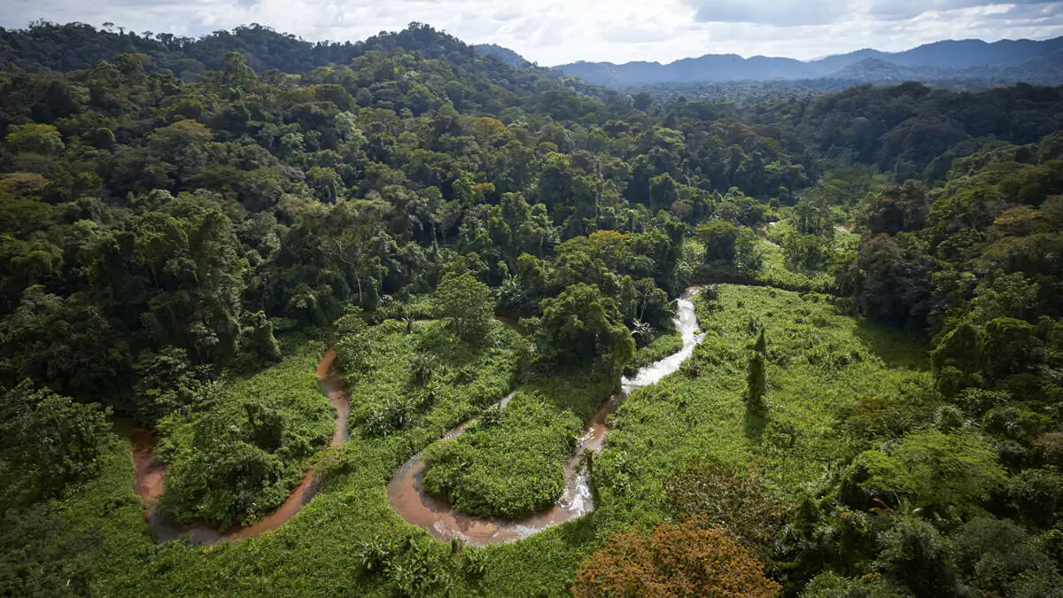
The natural landscapes of the Reserve correspond to three broad categories: coastal plains (less than 150 meters above sea level), high mountainous terrain (150 to 600 meters above sea level) and interior mountains (more than 600 meters above sea level). The coastal strip contains a labyrinth of lagoons, channels and mouths with large extensions of sandy beaches. To the south of the coast, between Barra Patuca and Brus Laguna there are swamps and, around the Brus and Ibans lagoons, there are still some mangrove areas.
Towards the south and interior of the Reserve, the terrain is more rugged and the orography is dominated by hills and, eventually, mountains. The Baltimore mountain reaches more than 1,000 meters above sea level at the height of Pico Dama; mountainous lands with hills and rocky topography cover the sources and interfluviums of the Paulaya, Plátano, Wampú and Patuca rivers.
Ethnic groups residing in the Biosphere
Four indigenous groups inhabit the Río Plátano; Garifuna, Miskito, Pesh and Sumo (tawakas). The Garifuna are a mixture of Africans with indigenous people from the Caribbean, the Miskitos are a mixture of Garifuna with indigenous Misquitos (Pesh and Tawakas) while the Pech (300 inhabitants) and Tawakas (800 inhabitants) maintain their communities with their traditional lifestyle. in remote regions of the biosphere. The largest ethnic group is the Miskitos.
The inhabitants of the area grow corn, beans, yucca, etc. To survive, they also live from hunting, fishing and the consumption of wild plants, using the latter mainly for medicine.
Flora and Fauna of the Biosphere
The broadleaf forest covers the Reserve with a predominant layer of very mature trees up to 35 meters high. Species such as mahogany (Swietenia macrophylla), cedar (Cedrella odorata), laurel (Cordia alliodora) and other colored woods are scattered in areas where there has been no forest use.
In the areas with altitudes of approximately 600 meters above sea level, the very humid tropical forest is found, composed of broad-leaved trees with a great diversity of life forms.
The gallery forests of colored wood are located on the banks of the rivers, far from any human settlement; swamp forests exist in alluvial and floodplains near the coast; swamps cover the northeast of the coastal strips and mangrove patches survive in specific places on the margins of the Brus and Ibans lagoons and on the banks of the channels; on the other hand, upland pine forests have a considerable area (approximately 6,000 ha).
The Reserve maintains a diverse and rich set of neotropical life, among which are many mammals and birds, species in danger of extinction or reduced in other parts of Central America. Important indicator species of the status of biodiversity such as the harpy eagle (Harpia arpija), the jaguar (Panthera onca) and the jaguia (Tajassu pecari) show that the reserve is still very rich in biodiversity and in some parts of it is still they keep their fauna and flora intact. The few studies indicate that there are probably about 400 species of birds and 200 species of amphibians and reptiles in La Reserva (Froehlich, etc. al. 1983)
Ecosystems in the Biosphere
25% of the biosphere is a coastal area covered by large mangrove areas, the two largest areas are found along the coast of Brus Laguna (120 km²) and Laguna de Ibans (63 km²), a large number of savannas and wetlands are found throughout the rest of the region.
About 75% of the biosphere are mountains with many ranges in height. Pico Morrañanga reaches 1,500 meters and Punta de Piedra 1,326 meters. Incredible geological formations are found in the mainland regions, such as El Viejo or Pico de Dama. Waterfalls and streams are found regularly, the highest (100-150 m) is the Cascada del Mirador at the head of the Cuyamel River. This immense area consists mainly of tropical rain forest.
Ecoregions
Different terrestrial and maritime ecosystems are represented in the Reserve, including five large ecoregions of which the first three are of exceptional value because they contain unique ecosystems of international importance:
- Wetlands Ecoregion with a great variety of systems such as: mangroves, lagoons, fresh and brackish water swamps, estuaries, swamp forests and the coastal strip.
- Sabana de Pino Ecoregion
- Atlantic Broadleaf Forest Ecoregion
- Tierra Alta Pine Forest Ecoregion
- Maritime Zone Ecoregion
The concept of Wetlands most frequently used today is that of the Ramsar Convention, which defines as an extension of marshes, swamps, peat bogs or natural or artificial waters, permanent or temporary, stagnant or flowing, fresh, brackish or salty, including extensions of seawater whose depth at low tide does not exceed six meters (IUCN 1990).
The Coastal Wetlands Ecoregion is the most diverse of the existing ones in the Reserve, presenting eight ecosystems: four aquatic and four terrestrial. The four aquatic ecosystems are salt-influenced lagoons; lagoons without salt influence; temporary ponds and canals.
Terrestrial ecosystems are swamp forests, swamp semi-deciduous forests, herbaceous swamp with palms, and mangrove forests. These ecosystems are united by the still waters of the lagoons that slowly flood everything around them (Environmental Diagnosis of the Reserve of Man and the Biosphere of Río Plátano, 2002).
These wetlands provide countless benefits, including: protection from tropical storms and hurricanes; control of flooding and erosion of river banks, canals, ponds and lagoons; the reduction of water pollution caused by sedimentation; the retention of nutrients in the subsoil and vegetation; the generation of a great variety of products for subsistence or commercialization such as fish and shellfish in general, birds, mammals, reptiles and forest products; regulation of the microclimate; the facilitation of transportation; in addition to high ecotourism potential.
The coastal pine (Pinnus caribaea) savanna is located in the lowlands and plains adjoining the coastal zone in the northeast and eastern part of the reserve, extending to the interior.
There is a large extension to the south of Brus Laguna and a small one that reaches the southeast margin of the Laguna de Ibans, where the pine grows among grasses, small palms and fire resistant trees. The savanna presents different types of vegetation, including patches of broadleaf forest and various types of grasses and savannas with palms.
The densest pine forests are found in some parts to the west and south of Brus Laguna. Mature pines can reach a height of 15 to 20 meters, which is the characteristic height of this species of pine. The forest canopy is open and the ground is generally covered with a dense layer of herbaceous vegetation and grasses.
Savannas make up a mosaic of pines, grasses, and shrubs. Plains and meadows dominated by lawns, herbaceous vegetation with few trees develop in these places; in the low and humid lands the grass reaches heights of four feet and in the higher and drier lands less than a foot. In other low areas, palms (Acoelorrhaphe wrightii) and swamp vegetation dominate. Galleries of broadleaf forest are found along riverbanks away from human settlements.
The origin of the Miskito pine savanna is not yet scientifically determined. It is recognized that the combination of recurrent fire episodes, as well as the physical characteristics of the soils, specifically their drainage properties, are important factors that determine their distribution. It is considered that if the fires were suppressed, other species from the broadleaf forest could colonize certain extensions of the pine savanna.
It is difficult to evaluate the effects of human activities in the pine savanna since its ecological dynamics is not well analyzed. However, wood extraction activities and the occurrence of natural or provoked fires are significant elements in the formation and maintenance of this area.
The savanna is home to a wide variety of birds such as ducks, piches and wattles, and severely reduced mammal species such as the white-tailed deer (Odocoileus virginianus), the jaguar (Panthera onca) and the puma (Felis concolor)
The broadleaf forests are found inland and above the pine plains, including lowland moderately drained broadleaf evergreen forests, well-drained broadleaf evergreen forests of the soft hills, submontane broadleaf evergreen forests, and lower montane broadleaf evergreen forests. These four ecosystems make up most of the extension of the Reserve and the entire Core Zone.
The broadleaf forest of the Core Zone is the largest in Central America. There is a great contrast between the Miskito pine savannas and the Atlantic broadleaf forest along the eastern side of the Reserve. In this sector, the lowland plains meet the eastern hills that extend from the mountainous regions of central Honduras.
The high mountains reach more than 1000 meters in elevation and the mountain ranges extend from the southeast to the northeast. The headwaters of many rivers are born in these mountains cutting deep valleys through their routes.
In this sector, the broadleaf forest, with some dominant deciduous species, forms a corridor 50 to 100 km wide, which extends from the coastal zone in the north to the southern limit of the Reserve.
The western side of this corridor is bordered by the settlement front, while on its eastern side is the Miskito pine savanna. Bands of broadleaf forest also form galleries, crossing the savannah along the courses of the rivers that are normally composed of secondary forest, which constitutes an infinity of internal natural corridors or allows a constant transit of animal species.
The broadleaf forest of the Reserve has undergone considerable human alteration; unfortunately very little is known about the ecology of this system.
According to studies by the Department of Protected Areas and Wildlife DAPVS, of the AFECOHDEFOR State Forest Administration, in the Ecoregion four new species of mammals were discovered in Honduras and others that had their geographic extensions known until then further north in the neotropical region within of the Reserve, placing it as an extremely important protected area in the concept of the Mesoamerican Biological Corridor.
The influences of hurricanes, winds from the north and tropical storms are scarcely investigated as important factors for the structure of the vegetation and as causes of the scarcity of some populations of mammals in the northern part of the Reserve.
The highland pine forest, characteristic of Honduras, is located in the southern part of the Reserve. Like the pine savanna, it is combined with shrub and grass vegetations, on the contrary it happens in the pine savannas where the predominant species is that of Pinnus caribea.
The Maritime Ecoregion consists of a strip of sea 65 km long and 5 km wide, bordering and facing the beach, within the limits set by the Río Plátano Biosphere Region in its northern zone. It is divided into three ecosystems: the sub-coastal (or seabed), the neritic (or exposed sea) and the rocky massif ecosystem.
It contains a rich biological diversity that includes leatherback sea turtles (Dermochelys coriacea) and a great variety of fish, including sharks (Carcharhinus spp.) Among others. Another of the species of great value in the maritime zone of the Reserve is the white shrimp (Peneaus schmitti), this migratory species spends most of its adult life in the areas of seagrass and reefs, it is generally exploited by boats fishing boats of the Bay Islands (Insular Department of Honduras).
Within the Reserve there are some coral reefs (apparently the most important in the north of the Barra de Brus), which are the habitat for lobster, shrimp, fish and sea turtles, including the hawksbill turtle (Eretmochelys imbricata). Despite its importance, there are no studies of the current state of the reefs.
Marine resources are generally exploited by people living outside the Reserve, using shrimp and fishing boats; the use of inappropriate nets and trammel nets have a strong impact on marine life. Although commercial fishing is normally restricted to the season established by the General Directorate of Fisheries (DIGEPESCA), Decree 170-97, which establishes the 3 miles from the beach as part of the legally protected Reserve, is not obeyed.
Discovery of the White City
In 2012 the government of Honduras announced that it had found the legendary Ciudad Perdida or Ciudad Blanca in the area of La Mosquitia.
A team of Honduran and American scientists, technicians, archaeologists and historians, using digital images, would have detected the existence of a city in ruins in the department of Gracias a Dios.
The finding was confirmed by the government through the Honduran Institute of Anthropology and History (IHAH) and the firm UTL Científico, after the implementation of an advanced aerial laser scanning system that allowed to observe the surfaces below the dense Honduran jungle forest. .
The archaeological find was made by scientific personnel after filming studies and topographic surveying of the subsoil of the area known as “Lost City or White City”, which were made with the so-called Air Detection technology of Light and Range Measurements (LIDAR by its acronym in English) that UTL Investigaciones has.
Dr. Steve Helkins, explained about the activities that were carried out in the area and about the possible presence of archaeological remains, while appreciating that the findings open the possibility of scientific research.
Some publications report that the Spanish conqueror Hernán Cortes made reference to the White City in 1526, in a letter he sent to King Carlos V and in which he claimed to have been informed about a great city, comparable for being magnificent with Tenochtitlán, in Mexico .
According to the data collected by different sources, the indigenous people called this site Xucutaco (in Nahuat) and Hueitapalan (in Mayan), and Cortés refused to go due to the impenetrability of the jungle.
According to some versions, for years the Pech ethnic group managed the existence of the “kaha kamasa” or the “white city”, defined as a fortress built in stone in the middle of the Honduran jungle of La Mosquitia, even more imposing than the Ruins of Copan.
The White City is believed to have been abandoned by its inhabitants around the middle of the 16th century, without the reasons being known with certainty. Around 1544, according to some notes, the Spanish bishop Cristóbal de Pedraza claimed to have crossed the jungle of La Mosquitia and reached a mountain from where he could contemplate an impressive indigenous city.
Other publications indicate that the place was forgotten until 1939, when the American Teodore Morde claimed to have been in the White City, from which he took evidence, however he did not give the location for fear that it would be invaded by treasure looters.
According to the investigation, the lost city could be within an area of around 5 square kilometers in the La Mosquitia region, where access by land, water and air is presumed to be impossible.
“You cannot have definitive access, you cannot enter by land, you cannot enter by rivers and it is very difficult to enter even by air because we are talking about an area highly populated with trees that have already been measured and that are more than 70 meters and that they are stuck with others, even by air it will be difficult to enter, ”said Virgilio Paredes, manager of the IHAH.
National Geography Documentary on the White City
Christopher Begley, associate professor of anthropology at the University of Transilvania, will use a grant from the National Geographic Society to film a documentary in Honduras titled The Lost City of Mosquito Coast: A Modern Struggle for the Past -La Ciudad Perdida de la Costa Misquita: A modern fight for the past.
This Lexington archaeologist received a grant from the National Geographic Society to advance his search for a “lost city” in Honduras, published the online newspaper Kentucky.com reproducing the news released by journalist Becca Clemons, of the Herald Leader.
Christopher Begley, associate professor of anthropology at the University of Transylvania, will use a 3-D technology and research grant to examine ancient artifacts in the rainforest near the coast of La Mosquitia. It is rumored that the Lost or White City of ancient times is located in that area.
Administered by National Geographic Mission Programs, the NGS / Waitt program provides grants of between $ 5,000 and $ 15,000 for exploratory research.
Begley and a team that includes photographer and documentary filmmaker Josh Howard and University of Kentucky engineering professor Larry Hassebrook will travel to Honduras next week to begin filming the documentary.
“What’s interesting is what it says about the present,” Begley said of the lost city legends. “This is deeply ingrained and continues to exist as a legend.”
Related
- Biosphere Reserve in the UNESCO World Heritage Site, (in English).


