Municipality of Potrerillos
Potrerillos is a municipality in the department of Cortés, Honduras.
In the statistical yearbook of Vallejo in 1889, its foundation is recorded as far back as 1835, but it became an official municipality in 1871 and was declared as such in 1875 during the administration of José María Medina.
Origin of its name: derived from the word «potreros» which means pastures.
General Information about Potrerillos
- Date of creation: It was inaugurated in 1871, according to documents held by the Municipality. Its jurisdiction was not specified until 1875.
- Territorial area: 95 km2
- Elevation: 50 meters above sea level
- Patron Saint Festival: September 29th, in honor of Saint Michael the Archangel
- Administrative Code (Geocode): 0505
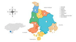
- Villages: 8
- Hamlets: 35
History
For a long time, the inhabitants of this jurisdiction lived in thatched huts near the Ulúa River. The creation of the municipality was a request from the residents and it was inaugurated in 1871, according to documents held by the Municipality.
The jurisdiction of the municipality was not specified until 1875, as follows: «To the North, towards the royal road of San Pedro and Tehuma, the Ulúa River; to the West, the El Suyatal Stream until it reaches the Grande de Ulúa River; to the Southwest, towards the royal road of Talpetate, the Real Paso of El Zapote Stream; and to the South, along the royal road of Yojoa, the houses of Caracol and Río Blanco, up to the place called Nazarito.»
Municipal Corporation
- Juana Aracely Pavón Alcerro – Mayor
- Román Arias Paz – Vice Mayor
- Carlos Noé Rivera Manzanares – Councilor
- Miguel Ángel Ferrera Banegas – Councilor
- Román García Gonzales – Councilor
- Karla Patricia Rodríguez Lagos – Councilor
- Lisandro Valentín Ramírez Guerrero – Councilor
- Wilfredo Canales Alfaro – Councilor
- Lourdes Suyapa Torres Gutiérrez – Councilor
- German Gonzales Hernández – Councilor
Location
The municipality is located 45 km south of San Pedro Sula and is part of the Metropolitan Zone of the Sula Valley. It has the shape of an inverted triangle, bordered by the municipalities of Pimienta and San Antonio de Cortés.
View on Google Maps
Territorial Extension
The territorial extension of Potrerillos municipality is 88.3 km2. The current territorial area is 95 square kilometers, of which 5.35 km2 correspond to the urban area and 83.05 km2 correspond to the rural area.
Topography
The municipality has a variety of topography, with altitudes ranging from 40 meters above sea level in the flat and lowlands to 350 meters above sea level.
Boundaries
- North: municipality of Pimienta;
- South: municipality of Santa Cruz de Yojoa;
- East: municipalities of Santa Cruz de Yojoa, El Progreso, and Santa Rita (the latter two in Yoro);
- West: municipality of San Antonio de Cortés.
Hydrography
Rivers
Due to its location and topographical features, Potrerillos has a considerable number of water sources, including the Ulúa, Blanco, and Comayagua Rivers.
Streams
- La Frescura, Las Ánimas, El Zapote, Manacal, Caracol, Quebrada de Agua, and Quebrada Guanaca
Climate
The climate is hot in the lowlands and pleasant in the higher areas. The average annual temperature is 26ºC, rising to 34ºC in the summer and dropping to 20ºC in the winter months.
Orography
- Cerro Brasta
Flora and Fauna
- The area is home to fruit trees such as tamarind, mango, corozo, nance, and pito; as well as ornamental trees such as acacia, guacamayo, and macuelizo.
- There are mammals, birds, reptiles, and geological formations with limestone, saltpeter, and sediments suitable for cement production. In the northern part of the municipality, there is a cave called La Leona.
Population
It has a total population of 23,677 inhabitants; of which 11,466 are men, 12,211 are women, 18,096 live in the urban area and 5,580 live in the rural area. In terms of its population, it ranks #9 in the department, with 1.5% of the population, and #72 in the country with 0.3% of the total population; 0.4% of the population belongs to an ethnic group. In the last 10 years, 391 people have left and live in another country.
In this municipality there are 13,270 people of 18 years and over, of which 95% have their identity card; this municipality has an illiteracy rate of 12% and a primary coverage of 95% with an average of 6.0 years of study, women heads of household represent 31% of the households, the masculinity index is 94 men for every hundred women, and the elderly population (65+ years) represents 4.5% of the population.
Economy
- 43% Manufacturing Industries
- 20% Agriculture, livestock, forestry and fishing
- 10% Wholesale and retail trade, vehicle repair
- 6.8% Construction
- 5.7% Transport and storage
- 15% Other activities
Agriculture
In the high areas, producers are mainly dedicated to the production of basic grains, in addition to some vegetable crops, often characterized by low yields due to soil erosion rates and degradation of natural resources that is quite high, however in the low areas there is a strong production oriented to sugar cane as the main item, also banana, rice, yucca and banana.
Unfortunately, the producing families are constantly affected by the effects of climate change through long periods of drought and/or floods that have occurred at key times for planting causing major losses in basic grain crops and rice, severely affecting the food security of these families.
Livestock
- Poultry, Bovine, Porcine, Equine
Industry
- Production of lime, textile maquiladora, carpentry, shoemaking, ceramics, jewelry, pyrotechnics.
References
- National Institute of Statistics (INE)
- Institute of Access to Public Information
- National Electoral Council (CNE)