Department of Valle
Valle is a department of the Republic of Honduras.
View Mapa of Department of Valle
Important Information About Valle
Origin of its name: To perpetuate the name of the Honduran Sage José Cecilio del Valle and as a tribute to his virtues and his work for the community, the new department bears the name «VALLE».
The marine national park Archipelago of the Gulf of Fonseca, is an area located between the maritime portion of the municipalities of Amapala and Alianza, in the department of Valle.
It has an area of 4,057 hectares and is a nesting area for a wide variety of native and migratory birds.
- Departmental capital: Nacaome
- Territorial area: 1665 km2
- Administrative Code: 17
- Population: 176,269 inhabitants (2012)
- Population density: 106 hab/km2
- Date of creation: July 11, 1893
History of Valle
The first inhabitants of the region of the current department of Valle were the Chorotegas, probably one of the last migrations from the center of Mesoamerica, Mexico. With the presence of the Spanish conquerors, the current territory of Choluteca comprised the indigenous province called Malalaca Choluteca.
In the list of towns of the province of Comayagua in 1684, the towns of Nacaome, Goascorán and Langue belonged to Choluteca. In the report of Bishop Cadiñanos in 1791, it is known as the parish of Goascorán. In the report of the intendant Ramón Anguiano in 1804, the territorial area of Valle was known as the holding of Nacaome.
In 1872, during the government of Céleo Arias, the department of La Victoria was created, which had a short-lived existence; it wasn’t until July 11, 1893, during the government of Domingo Vásquez, that the department of Valle was created, being ratified by Congress in September of the same year.
It would be made up of Nacaome and Goascorán, formerly of the district of Choluteca and Caridad. Its name is attributed to the illustrious Honduran patriot, who drafted the Act of Independence of Guatemala on September 15, 1821.
The territory that makes up this department, in the first Territorial Political Division of 1825, belonged partly to the department of Comayagua and partly to Choluteca.
In 1869, with the creation of the department of La Paz, part belonged to La Paz and part to Choluteca. This territory was assigned to create a new Department with the name «Victoria» on July 15, 1872, with Doctor Céleo Arias as president of the Republic; however, less than two years later, on April 29, 1874, the current government abolished it.
This dissolution cost it the loss of the territory occupied by the municipality of Pespire, which was incorporated into Choluteca in 1879.
The definitive creation of Valle was on July 11, 1893, with General Domingo Vásquez as the constitutional president, giving it that name, in honor of the Procer José Cecilio del Valle.
Geography of Valle
The department of Valle is located in the southern part of the Republic. The territory borders El Salvador to the west, the Gulf of Fonseca to the southwest, Francisco Morazán and La Paz to the north; the climate of this area is known for being very hot in summer and rainy in winter. The department has a surface area of 1,665 km² and an estimated population of 160,346 inhabitants in 2005.
Boundaries
- North: La Paz and Francisco Morazán Departments
- South: Gulf of Fonseca;
- East: Department of Choluteca
- West: Republic of El Salvador.
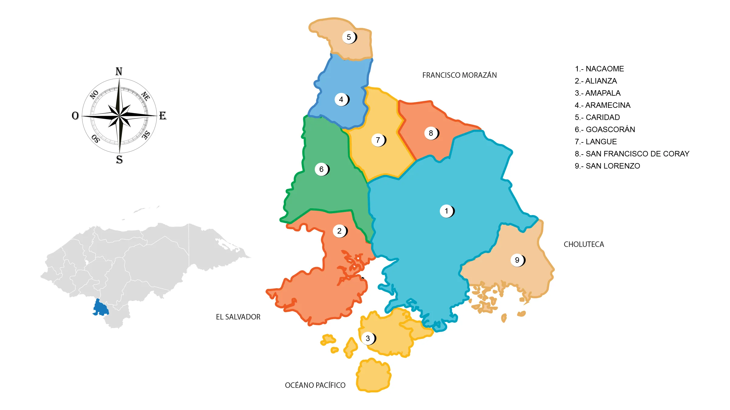
Municipalities of Valle
See List of Municipalities of Honduras
- Alianza 1702
- Amapala 1703
- Aramecina 1704
- Caridad 1705
- Goascorán 1706
- Langue 1707
- Nacaome 1701 Cabecera departamental
- San Francisco de Coray 1708
- San Lorenzo 1709
Rivers: Nacaome, originates south of the Lepaterique mountain, with the name of Río Grande de Reitoca near Choluteca, collecting the waters of the Moramulca River, passes near Pespire, joining the Río Chiquito, penetrates the department of Valle.
Where it is increased by the Goascorán rivers, it originates in the mountains of Rancho department of La Paz, heads South, then it is known by the name of San Juan River until the coast, where it is called Goascorán, it flows into the Gulf of Fonseca and serves as the border between Honduras and El Salvador. There are also Guasirope, Simisirán, Laure, Aramecina(apasapo) and Solubre rivers.
Protected Areas: Marine national park, Chismuyo Bay, San Lorenzo; multiple use reserve, Tiger Island; species management area, Mico Quemado.
Islands: Tigre, Conejo, Almejas, Zacate Grande, Exposición, Güegüensi, and Garrobo.
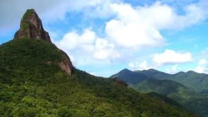
Mountain ranges: Estribaciones and Lepaterique.
Valley: Goascorán Valley and the Plains: San Rafael, El Corcovado, San Lorenzo, El Coyol, and El Alto de los Toros.
Hills: It can be said that it has no mountains, as the branch that separates from the main Lepaterique mountain range heading south forms the mountains of Azacualpa (Curaren) that die with the Manzanilla mountain north of Langue, after that there are only hills, the highest being Moropocay, almost north of the city of Nacaome; it extends from east to west between Moroiica and Coray. Following are the hills: Moropocay, Higuito, Volcancito, Loma Chata, San Juan, El Picacho, Goascorán, and Capulín.
Islands: Garrobo, San Carlos, Exposición, Violín, Sirena, Comandante, El Padre, Las Almejas, Los Pájaros, Pacar, Coyote, Inglesera, Conejo, Zacate Grande, and El Tigre, with the last two being the largest.
Fauna and Flora of Valle
Mammals: shrew, squirrel, coati, agouti, skunk, raccoon, deer, tepezcohuite, wild boar, coyote, fox, wild cat, puma, ocelot, and jaguar.
Avifauna: woodpecker, oakland pheasant, ocotera dove, roadrunner or dog soul, magpie, grackle, quail, torcasa, parakeet, taragón or guardabarranco, heron pelican, albatross, goldfinch, hawk, vulture, owl, and osprey.
Marine Species: crab, shrimp, blue crab, curiles, manta ray, and a great variety of fish.
Flora: mangrove forests, guanacastes, common ceiba, amates, jícaros, and thorns.
Economy of Valle
Its industry consists of manufacturing items from agricultural products, as well as the manufacture of salt. Here is located the only port that Honduras has to the South in the Pacific, Amapala.
Industry: saltpans, nursery fish, and shrimp.
Commerce: San Lorenzo and Nacaome. Mines: gold, iron, and silver.
Production: watermelon, melon, mango, forage sorghum, and millet.
Breeding: cattle, horses, pigs, and goats.
Water resources: Pespire or Nacaome river dam.
Tourism in Valle
- Amapala Island
- Mangrove forests in Chismuyo Bay
- Birdwatching on Bird Island
From Amapala, you can sail to the beaches of Punta Ratón, Cedeño (from October to November in these two places newly hatched Golfito turtles are released), Las Gaviotas, or Delgaditos.
You can visit the attractive mangroves of the San Lorenzo and Chismuyo bays. Sport fishing is practiced by many tourists who visit the area.
Besides enjoying the landscape of these islands, their caves, and the extraordinary sunsets of the Golfinos, there are also various opportunities to taste crustaceans, mollusks, and seafood typical of the Honduran Pacific.
From the Coyolito dock, you can enjoy a boat tour of this area, which usually lasts 2 hours. In Amapala there are several hotels, restaurants, guesthouses, and beaches that can be enjoyed as part of ecotourism in this region.