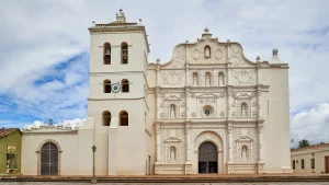
Municipality of Oropoli
It is a municipality in the Department of El Paraíso, in the Republic of Honduras.
The history of this town is linked to the Pre-Hispanic period, as evidenced by the petroglyphs at the Orialí site. However, it has been recorded as a municipality since 1711 during the Colonial period. In 1845, it was destroyed during a revolution and reduced to a village. It was not until 1865 that it regained its municipality status, and in the political territorial division of 1889, it was part of the Yuscarán district.
General Information about Oropolí
Origin of its name: In the Mesoamerican language, it means «river of the big corn cobs.»
- Territorial area: 158.85 km2
- Population: 6,015 inhabitants (2012)
- Date of creation: 1711
- Patron saint fair: March 19, feast day of Saint Joseph.
- Villages and hamlets: 10 villages and 37 hamlets.
- Altitude: 470 meters above sea level.
Main Economic Activity
Cultivation of basic grains, vegetables, melons, watermelons, and sugarcane; breeding of cattle, horses, and pigs; poultry farming.
Infrastructure
- Health: 3 CESAR (Rural Health Care Centers).
- Education: 20 primary schools, 5 pre-basic education centers, 2 basic education centers, 7 kindergartens, and 1 secondary school.
- Transportation: Buses that connect from the capital to Yuscarán.
Location
Located among hills and canyons, very close to the Yuscarán municipality.
Limits
- North: municipality of Yuscarán;
- South: municipalities of San Lucas and San Antonio de Flores;
- East: municipality of Alauca;
- West: municipality of Güinope.


