Department of El Paraiso
El Paraíso is a department of Honduras. Until 1878 it was part of Tegucigalpa. Origin of the name: historical-cultural name «Paradise», evoking the biblical place of creation.
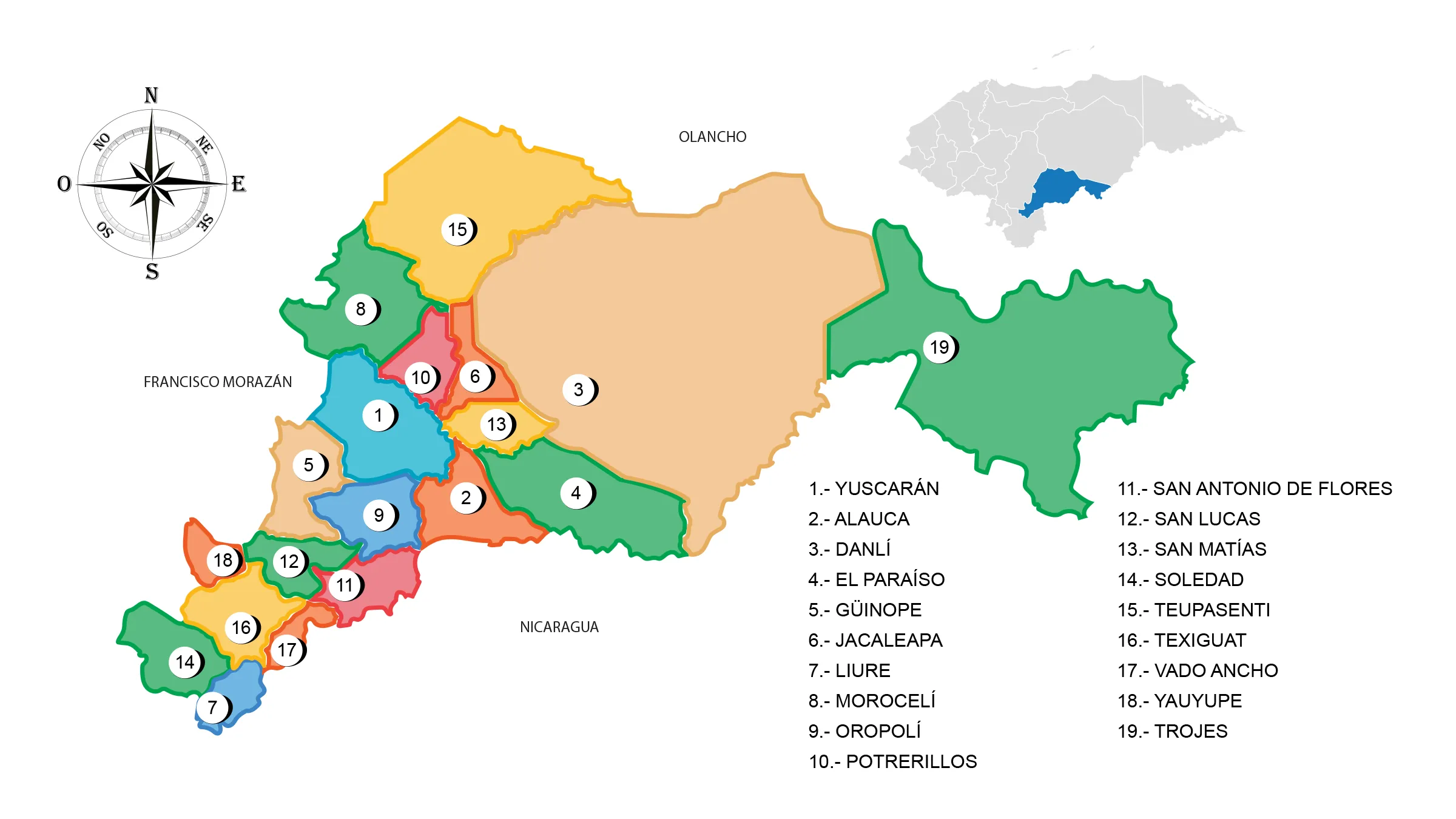
View Map of Department of El Paraiso
Datos Generales
- Departmental head: Yuscarán
- Territorial surface: 7489 km2
- Administrative Code: 07
- Population: 445,122 inhabitants (2012)
- Population density: 58 inhabitants/km2
- Creation date: May 28, 1869.
History
The first settlers of the current department of El Paraíso were located in the vicinity of the cultural border between the Mesoamerican area and the intermediate or circum-Caribbean area, in the Pre-Hispanic period, some ethnologists called them El Paraíso Indians. At the time of contact, the territory of El Paraíso was included in the indigenous province of Olancho. The exploitation of minerals in the second third of the 18th century, in the Yuscarán area, brought with it the development of agricultural and livestock activities in the area, which lasted until the 19th century, increasing internal and external trade through the port. of Amapala, located in the south of the country. It was created in the government of José María Medina in 1869 together with the departments of La Paz and Copán. One of the industries with the greatest movement is the distillation of brandy, as well as modest mining, local products such as melon, tobacco and corn.
Geography
Location: it is located to the east of the country.
Boundaries
- North : department of Olancho
- South: Department of Choluteca and the Republic of Nicaragua
- East: Republic of Nicaragua
- West: Department of Francisco Morazán.
Important rivers: Jalán, Guayambre, Choluteca, Guayambre river basin, Jalán river basin, Protected areas : Danlí water protection zone and Monserrat biological reserve. Sierras: to the southeast is the Sierra de Dipilto, Misoco, del Chile, Lepaterique. Mountains: Dipilto, Jalapa, Río Frío, Río Guano, de Almendares, Azacualpa and Narijupe.
Municipalities
See List of Municipalities of Honduras
- Yuscarán 0701
- Alauca 0702
- Danlí 0703
- El Paraíso 0704
- Güinope 0705
- Jacaleapa 0706
- Liure 0707
- Morocelí 0708
- Oropolí 0709
- Potrerillos 0710
- San Antonio de Flores 0711
- San Lucas 0712
- San Matías 0713
- Soledad 0714
- Teupasenti 0715
- Texiguat 0716
- Vado Ancho 0717
- Yauyupe 0718
- Trojes 0719
Fauna and Flora
Mammals: shrew, squirrel, coatis, guazalo, skunk, raccoon, deer, tepezcuintle, tapir or tapir, mountain pig, coyote, foxes, wild cat, puma, ocelot and jaguar. Avifauna: woodpecker, oak pheasant, ocotera pigeon, roadrunner or dog soul, magpie, grackle, quail, torcasa, parakeet, tarragon or mockingbird guard, goldfinch, hawk, bearded vulture and owl. Flora: broadleaf pine forests.
Economy
Main economic activity: cultivation of coffee, mango, potato, tomato, melon, tobacco, watermelon, corn, soybean, cornstarch and beans; raising cattle, horses and pigs; Industry: alcoholic beverages, tobacco, meat processing, leather and furniture; gold and silver deposit. Commerce: Danlí, El Paraíso and Yuscarán.
Tourism
- Corn Festival in Danlí
- Historic center of Yuscarán
- Orialí rock art site
- Hot Springs
- mining center


