Geographic Regions of Honduras
Geographically, Honduras is divided into multiple regions, each displaying unique characteristics based on their territorial extension, landforms, economic and production activities, as well as population centers.
Located in the center of the Central American region, the Republic of Honduras is the second-largest country in the area.
Click here to see the Map of Health Regions in Honduras.
See also Mountains of Honduras.
Geographical Position of Honduras
Honduras is physically bordered by three countries and two oceans, but paradoxically it has been one of the most isolated countries in the region due to its complex terrain.
With a surface area of 112,492 square kilometers, Honduras shares borders: to the west with Guatemala (340 km) and El Salvador (356.5 km), to the north with the Caribbean Sea (650 km), to the east with Nicaragua (575 km), and to the south with the Pacific Ocean (65 km).
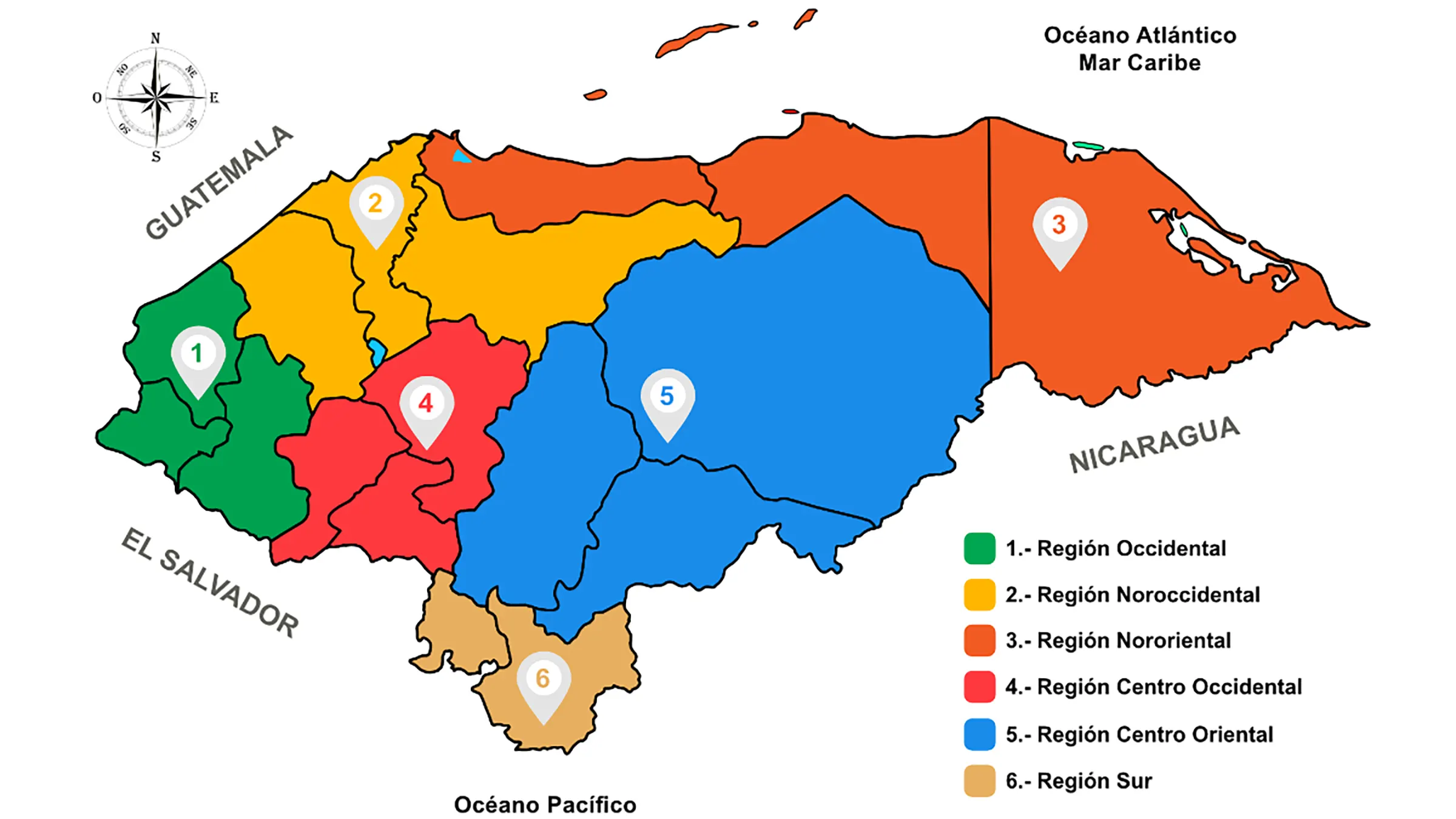
Honduras has six geographical regions
1. Western Region
The western region, consisting of the departments of Ocotepeque, Copán, and Lempira, is a mountainous region with the Merendón, Gallinero, and Espíritu Santo mountain ranges and very narrow valleys.
The main urban center is Santa Rosa de Copán. The economic activity revolves around agriculture, with main products being corn, coffee, tobacco, as well as livestock. The majority of the population is mestizo, with Chortis ethnic groups and peasant communities of Lenca tradition also present.
2. Northwest Region
This region is made up of the departments of Cortés, Santa Bárbara, and Yoro. It is a region of valleys and mountains, with the Nombre de Dios, Sulaco, Gallinero, Omoa, Atima, and Mico Quemado mountain ranges crossing through it.
The most important city is San Pedro Sula. The economic activities include the cultivation of oranges, sugarcane, bananas, vegetables, as well as cattle farming and its derivatives. It is also the country’s main industrial center, generating significant tax revenue. The city is home to Puerto Cortés, the country’s main seaport.
3. Northeastern Region
The northeastern region is composed of the departments of Atlántida, Colón, Gracias a Dios, and Islas de la Bahía. Its relief consists of the Caribbean coastal plain and the Nombre de Dios mountain range. The main cities in this region are La Ceiba, Tela, Trujillo, Tocoa, and Roatán. The economic activity is based on crops such as African palm, citrus fruits, coconuts, bananas, pineapples, and yuca. Livestock farming, fishing, timber exploitation, and tourism are also important. The inhabitants include Miskito, Pech, Tawahka, and English-speaking Creole or Afro-Caribbean communities.
4. Central Western Region
The central western region is made up of the departments of Intibucá, Comayagua, and La Paz. Its relief is formed by the Comayagua, Montecillos, Opalaca mountain ranges, as well as the plateaus of Siguatepeque and La Esperanza. The main agricultural products include potatoes, coffee, strawberries, and peaches. Additionally, vegetables, tomatoes, and mangoes are also grown. Comayagua is home to the country’s second cement manufacturing plant.
5. Central Eastern Region
This region is formed by the departments of Francisco Morazán, El Paraíso, and Olancho. It is characterized by the Lepaterique, Misoco, Agalta, La Esperanza, and Comayagua mountain ranges. The city of Tegucigalpa serves as the country’s political center, hosting the executive, legislative, and judicial branches of government. Other important cities in this region include Juticalpa, Catacamas, Danlí, and El Paraíso. The main economic activities include tourism services, textiles, maquilas, agriculture, livestock farming, and timber production. There are also natural reserves in this region.
6. Southern Region
The southern region is the smallest region in the country and is formed by the departments of Choluteca and Valle. Its relief consists of the Pacific coastal plain and the foothills of the Dipilto and Lepaterique mountain ranges. The prominent cities in this region are Choluteca, Nacaome, San Lorenzo, and Amapala.
The main economic activities include agro-industry, shrimp and cotton cultivation and processing, and beef production. In agriculture, they produce watermelons, cantaloupes, and sugarcane.
Recently, the tourism industry has flourished due to its proximity to the capital city, with notable beaches in Amapala such as Coyolito, Playa Negra, and others.
Additionally
- See Geography of Honduras
- See Municipalities of Honduras by Department
- See Health Regions of Honduras (Map)
- See Coffee Geographical Regions in Honduras


