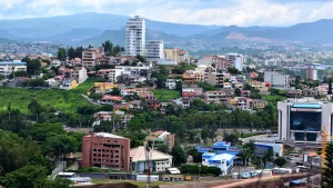
City and Municipality of Choluteca
It is the departmental capital of the Department of Choluteca, in the Republic of Honduras.
Spanish chroniclers date the year 1526 as the foundation of the settlement, giving credit to Juan de la Cueva, a soldier of the conquistador Pedro de Alvarado, although others mention the new foundation in 1534.
By 1580, the jurisdiction of Choluteca was incorporated into the mayor’s office of Tegucigalpa, consolidating the southern region of the province of Comayagua due to mining discoveries in its jurisdiction. It obtained the status of the town of Xeres de la Frontera de Choluteca and was given the category of municipality on June 28, 1825.
General Information about Choluteca
Origin of its name: In the Mesoamerican language, Cholollan means «Cholula.»
- Territorial area: 1069.10 km2
- Population: 178,779 inhabitants (2012)
- Date of creation: 1534
- Patron saint festival: December 8, day of the Immaculate Conception.
- Villages and hamlets: 25 villages and 247 hamlets.
- Altitude: 35 meters above sea level.
Main economic activity
Cultivation of sugarcane, coffee, cashew, pineapple, vegetables, and staple grains; raising of pigs, cattle, and horses; poultry farming.
Location
Crossed by the Grande or Choluteca River, the Pan-American Highway passes through the municipality’s capital, connecting the borders of El Amatillo and La Fraternidad.
Limits
- North: municipalities of Pespire, Orocuina, and Apacilagua;
- South: Republic of Nicaragua;
- East: municipalities of Santa Ana de Yusguare, Namasigüe, and El Triunfo;
- West: municipalities of Marcovia and San Lorenzo (Valle) and the Gulf of Fonseca.