Pico Bonito National Park
Pico Bonito is a mountain that lies behind the coastal city of La Ceiba in Honduras.Since January 1, 1987 it was established as a protected natural park. It has an area of 564.30 square kilometers.
See also Tourism in the Pico Bonito National Park
Its area of influence includes the municipalities of La Ceiba, Jutiapa, El Porvenir, Esparta, La Masica, San Francisco and Tela, within the department of Atlantida, as well as the towns of Arenal and Olanchito in the department of Yoro.
Location
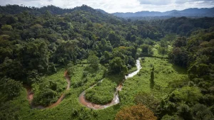
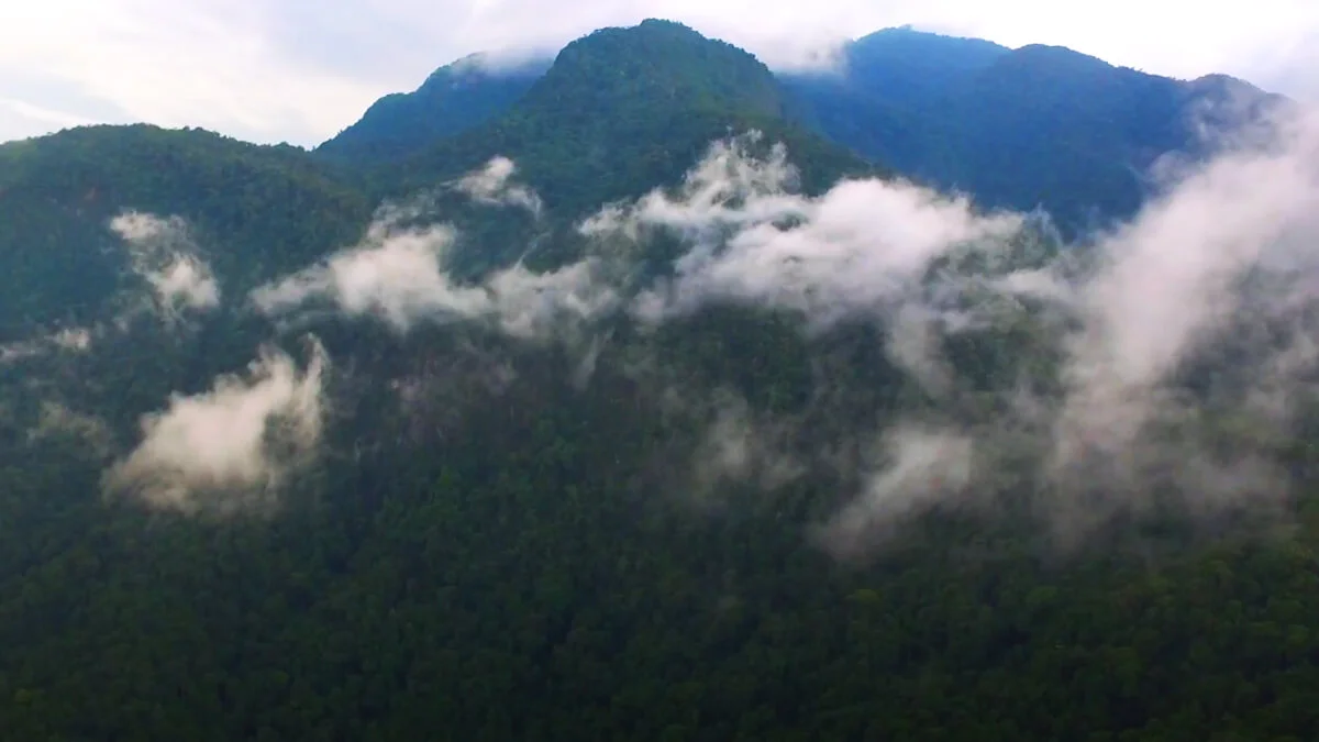
It is one of the richest national parks in biodiversity in Honduras.Starting in the coastal lands and going up to 2,436 meters above sea level, the park has a diversity of ecosystems that is still unexplored. It is located in the Sierra Nombre de Dios and has an area of 1,073 square kilometers.The park gets its name thanks to one of its two peaks (Pico Bonito is perhaps the most difficult mountain to climb in the country).
On this huge evergreen mountain (perhaps the highest mountain facing the Caribbean Sea from Colombia to Florida), wildlife is present at all times. Jaguars, boas, monkeys, and deer are constant characters. Along with them, hundreds of species of flora are still waiting to be discovered by science.
Pico Bonito is a symbol of La Ceiba and Honduras. Forty-six rivers flow from its heights that flow into the Caribbean Sea. One of them, the Cangrejal River, is famous for the strength of its currents, which allows the practice of rafting.
It was in 1974 that a group of professors from the Northern Regional University Center (CURLA) presented the idea of protecting Pico Bonito, but unfortunately the idea could not be implemented and it is in 1977 when the Directorate of Renewable Natural Resources (RENARE) proposes that the Pico Bonito area be declared a protected zone, based on an inventory of wild areas in the country, but without obtaining any type of result.
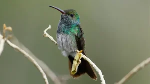
Each type of vegetation has associated fauna that is its own and due to its diversity of life zones in the park you can see a great variety of animal species such as the great variety of tropical birds, among which you can list toucans, swallows, pajuiles, ospreys, turkeys, different types of parrots and parrots, woodpeckers, orioles, it is possible to observe Quetzals in some areas.
Responsible bodies
The organizations responsible for the protection of this area are, first of all, the Non-Governmental Organization called Fundación Pico Bonito (FUPNAPIB) who work in the protection of flora, fauna, water resources, forestry and support to communities through charitable projects. .
Secondly, the state of Honduras with the Forest Conservation Institute (ICF) through the Department of Protected Areas and Wildlife provides support to the organization when it requires it, also the commonwealth of municipalities gives some support to the area.
Maximum and minimum heights
The most outstanding heights are a little more than 2,436 meters above sea level, this height is the maximum for the park. The minimum heights start from 20 meters above sea level.
Approximate temperatures
The temperatures of the park are very stable and it is generally 27 degrees Celsius, at night they can drop to less than 23 degrees.
Forest type
The Pico Bonito National Park is made up of
- Lands without forest
- Broadleaf forest (63.8%)
- Mixed forest
- Sparse coniferous forest
- Dense coniferous forest.
Ecosystems
The map of plant ecosystems of Honduras says that the park is composed of eight ecosystems:
- Agricultural System
- Lowland broadleaf evergreen tropical forest, well drained
- Evergreen broadleaf tropical forest, submontane
- Lower montane mixed evergreen tropical forest
- Mixed evergreen tropical forest, altimontano
- Lower montane spiky seasonal evergreen tropical forest
- Mixed semi-deciduous tropical forest, submontane
- Lowland microlatifoliate deciduous shrub, well drained.
Life Zones
The park has five life zones according to Holdridge and they are:
- Tropical dry forest (bs-T)
- Subtropical humid forest (bh-ST)
- Low montane very humid forest (bmh-MB)
- Subtropical very humid forest (bmh-ST)
- Tropical humid forest (bm-T).
The largest territorial coverage corresponds to the subtropical very humid forest (bmh-ST)
Flora and fauna
Among the plant species are Cedros, Redondos, Granadillos, Ceibas, Guayacán, Barba de Jolote, Laurel, Mountain Cypress, Sangre Real, Varillo among others.
In the park there is a great variety of wildlife such as (reptiles, birds, mammals, amphibians), much of which is in the category of threatened or in danger of extinction. The presence of Danto (Tapirus bairdii) White-tailed Deer (Odocoileus virginianus), Tiger (Panthera onca), paca (Agouti paca); Anteater (Tamandua tetradactyl); Wild pig (Tayassu tajacu), White-faced Monkey (Cebus capuccinus,) Howler Monkey (Allouata palliata); Goldfinch (Myadestes unicolor). Black Guan (Penelopina nigra). Birds like: Pajuil (Crax rubra); Black Duck (Cairina moschata); Quetzal (Pharomachrus mocino); Guan (Penelope purpurascens), Lora (Amazona ochrocephala).
Reptiles such as: Yellow Beard in the lower areas no greater than 1500 meters above sea level True and false corals, Timbos, various species of pichetes or lizards, about 45 species of amphibians and birds such as Quetzals, goldfinches, Black ducks, Mount Guan , Pajuiles among others.An immense quantity of insects of which they have not been very studied.
Communities
The communities that exist in the park’s limits are named as follows: Cabo de Hornos, El Cielo, El Zapote, Las Palmas, Tegucigalpita, La Ausencia, La Presa, El Cayo, La Primavera, Las Delicias, El Aguacate, El Portillo, Lanza, Manga Seca, La Llorona, Santiago Arriba, El Recreo and La Audiencia.
Current Land Use
The use that is currently given to the soil includes forest use but without exploitation, it is divided into very small patches of confiera forest, traditional agriculture and pastures.The greatest use corresponds to the forest protection of broadleaf forest
Hydrology
The hydrology of Pico Bonito is of great importance since it is a water-producing area, it has more than 80 streams that provide water and this is used by several communities, this water drains its waters providing flow to the Aguán, Perla, Cuero, rivers, Cangrejal, Viejo y Blanco.
Basin to which they belong
The park is located between the Leán, Cangrejal and Aguan basins.
Landslide Zones
Due to its very rugged topography, the park has numerous landslide areas, so great care must be taken in very rainy seasons.
Related
- List of Protected Areas and Parks of Honduras
- Tourism in the Pico Bonito National Park
- Municipality of La Ceiba