Department of Ocotepeque

The department of Ocotepeque is one of the 18 departments that make up the Republic of Honduras.
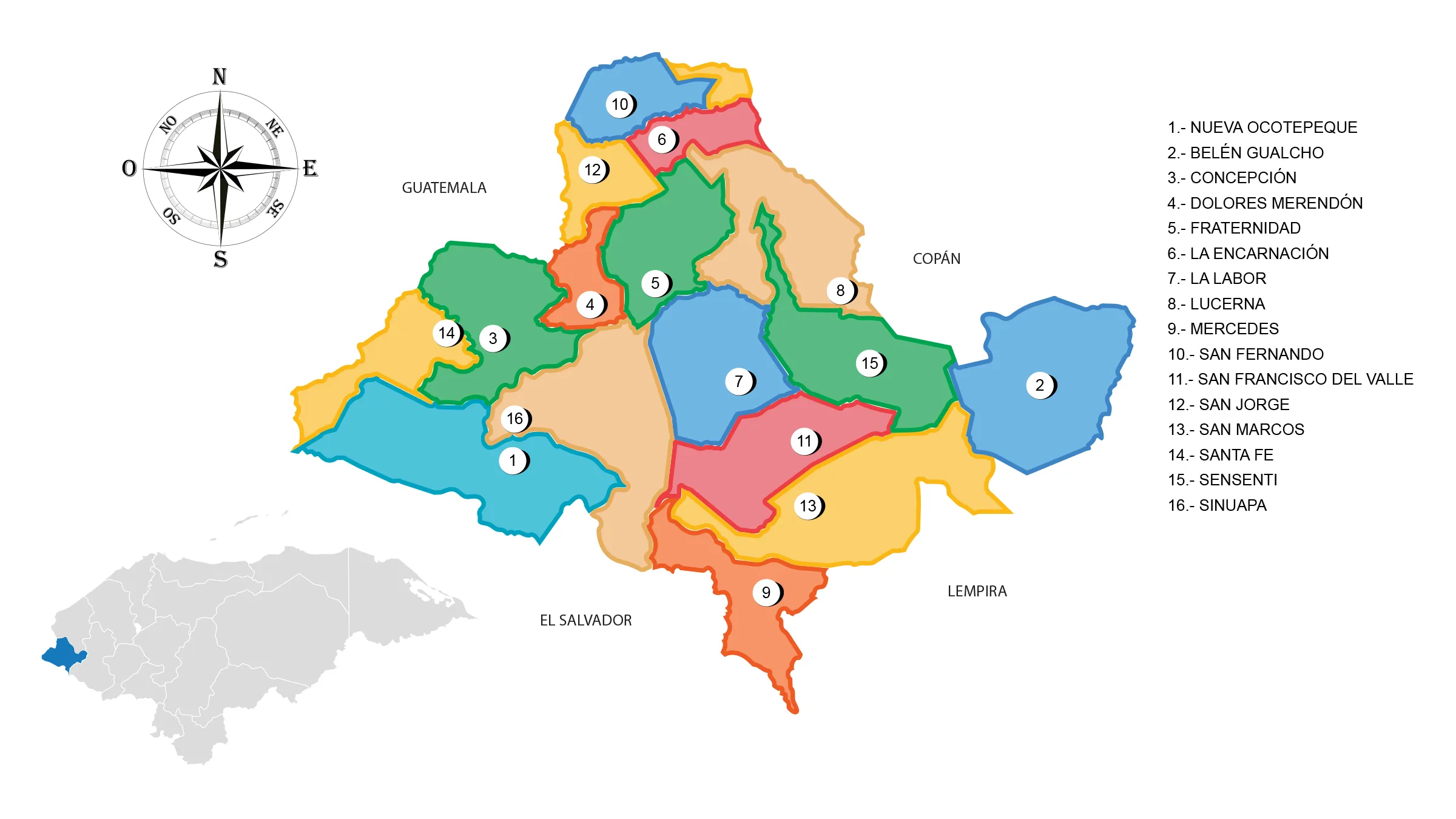
View Map of Department of Ocotepeque
About Ocotepeque
Origin of its name: In Mesoamerican language, it means «hill of pines.»
- Departmental capital: Ocotepeque
- Land area: 1630 km2
- Administrative Code: 14
- Population: 138,208 inhabitants (2012)
- Population density: 85 inhabitants/km2
- Date of establishment: February 20, 1906.
History of Ocotepeque
The first inhabitants of the department were the Chortís, a subgroup of the Mayan culture in the western part of Honduras, with a slight extension into the Republic of Guatemala.
The Chortí group is associated with the Mayans who developed an important culture in the Ruins of Copan. This is through the union of the founder of Copan, known as Yax Kuk Mo, with a princess from the Chortí lordship in the 5th century AD.
Ocotepeque was an Indian village assigned to King Felipe II in the jurisdiction of the city of Gracias a Dios in 1582; it was also a town of the party of Gracias a Dios in 1684.
In Fernando de Cadiñanos’ visit in 1791, it is known as the curate of Ocotepeque. In Anguiano’s report of 1804, it is a neighborhood of the tenure of Sensenti; by 1889, it belonged to the Copan department.
In the first Territorial Political Division in 1825, it was part of the party of Santa Rosa de Los Llanos (today Santa Rosa de Copan), department of Gracias.
The Constituent National Assembly by Decree Nº 106 dated February 20, 1906, created the Department of Ocotepeque with the districts of Ocotepeque and Sensenti, with the President of the Republic being General Manuel Bonilla, and President of the National Assembly Doctor Fausto Dávila.
Geography of Ocotepeque
It is located in the most western part of the country.
Limits
- North: Department of Copán
- South: Republic of El Salvador
- East: Department of Lempira
- West: Republic of Guatemala.
Municipalities of Ocotepeque
See List of Municipalities of Honduras
- Nueva Ocotepeque Cabecera departamental 1401
- Belén Gualcho 1402
- Concepción 1403
- Dolores Merendón 1404
- Fraternidad 1405
- La Encarnación 1406
- La Labor 1407
- Lucerna 1408
- Mercedes 1409
- San Fernando 1410
- San Francisco del Valle 1411
- San Jorge 1412
- San Marcos 1413
- Santa Fe 1414
- Sensenti 1415
- Sinuapa 1416
Rivers: Lempa, Sensenti, and Higuito.
Protected Areas: National Parks, Trifinio or Monte Cristo and Celaque; wildlife refuge, Erapuca; Biological Reserves, El Pital, El Güisayote, and Volcano Payaquita.
Mountain Ranges: Merendón and Celaque.
Mountains: Payacal, Cayaguanca, Portillo, El Pital, and Sumpul.
Wildlife and Flora of Ocotepeque
Mammals: shrew, squirrel, coati, guazalo, skunk, raccoon, deer, paca, tapir or danto, spider monkey and howler monkey, wild boar, coyote, fox, wild cat, puma, ocelot, and jaguar.
Avifauna: woodpecker, oak pheasant, pigeon ocotera, roadrunner or dog soul, magpie, grackle, quail, dove, parakeet, taragón or guardabarranco, mockingbird, goldfinch, quetzal, thrush, parrot, and hawk.
Flora: Forests of pine, oak, holm oak, fir, and broadleaf forest.
Economy of Ocotepeque
Production: Cultivation of coffee, potatoes, onions, cabbage, tobacco, rice, and sugarcane; raising of cattle, horses, pigs, and sheep; poultry farming.
Industry: crafts.
Commerce: Ocotepeque and San Marcos.
Mines: gold, silver, antimony, copper, and zinc.
Tourism in Ocotepeque
- Church of San Manuel de Colohete
- Church of San Matías de La Campa and Martyr City.


