Municipality of Marcala
The municipality of Marcala belongs to the Department of La Paz.
In the report of the governor of the province Alonso de Contreras Guevara in 1582, it appears as an indigenous village with twenty tributaries. Later it was called Capiro and was settled by residents from Chinada, as stated in the ecclesiastical census of 1791.
In the statistical yearbook of 1889, it appears as a municipality obtained in 1834 and already with its current name. When the Department of La Paz was created, it remained within this jurisdiction.
General Data of Marcala
Origin of its name: in Mesoamerican language, it means «place of prisons».
- Territorial area: 220.70 km2
- Population: 36,519 inhabitants (2012)
- Date of creation: 1834
- Patronal fair: September 29, feast day of San Miguel.
- Villages and hamlets: 2 villages and 55 hamlets.
- Elevation: 1225 meters above sea level.
- Climate: rainy with very dry winters.
Main Economic Activity
Cultivation of basic grains, coffee, sugarcane, citrus fruits, cardamom, and vegetables; raising of cattle, horses, goats, sheep, and pigs; poultry farming.
Location
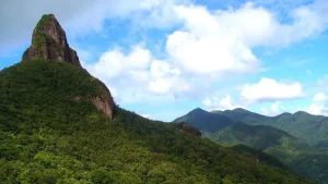
Located in a plain surrounded by mountains, bordering the south with the Republic of El Salvador.
Limits
- North: municipalities of Intibucá and La Esperanza (Intibucá);
- South: Republic of Salvador and municipality of Cabañas;
- East: municipalities of Santa Ana, Chinada, San José, and Opatoro;
- West: municipality of Yarula.
Hydrography: Chiflador River, Guaralape, Perea, and Negro or Chinancla.