Department of La Paz
La Paz is one of the 18 departments into which Honduras is divided. Its capital is the city of the same name.
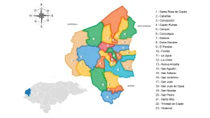
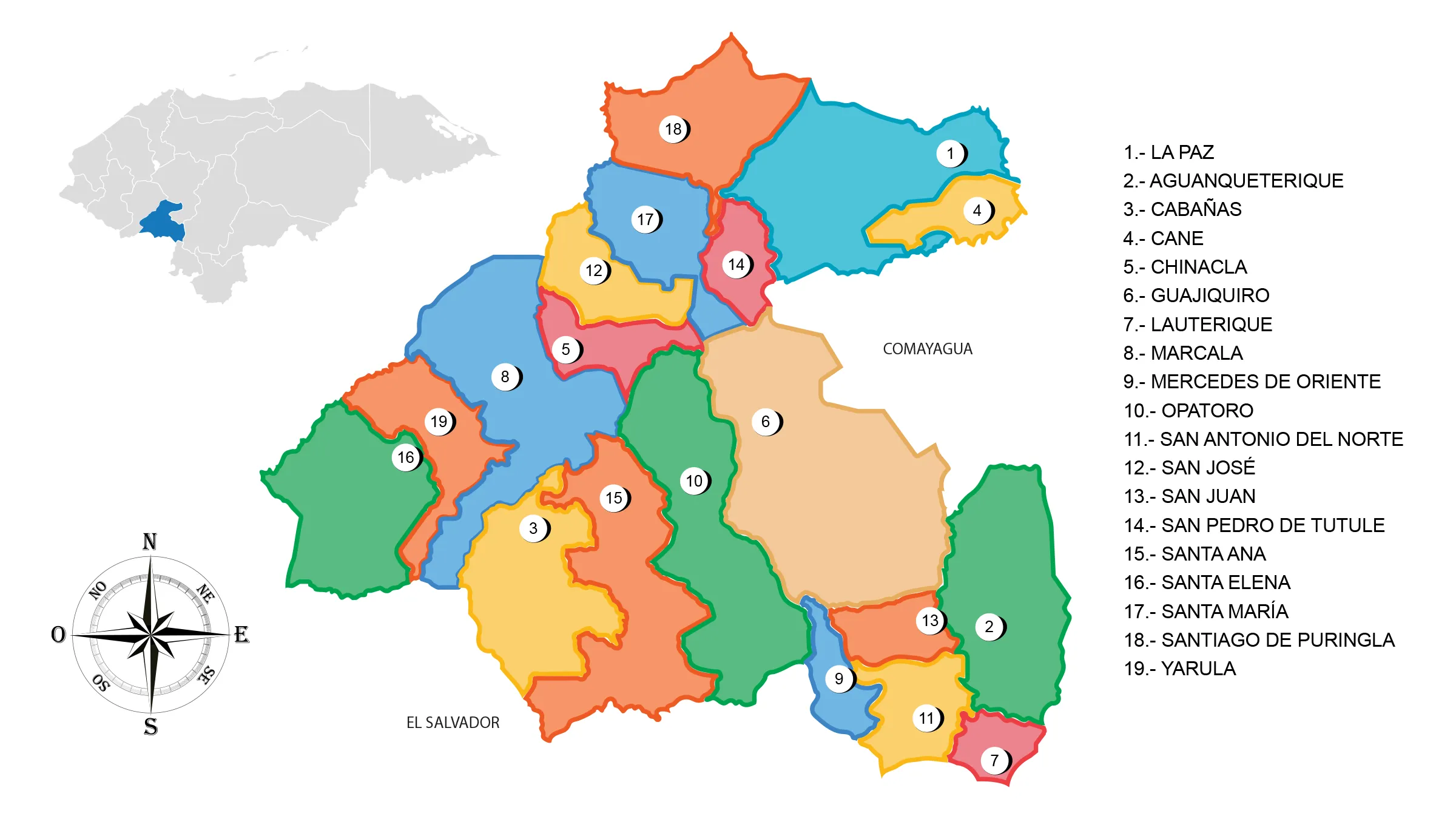
View Map of Department of La Paz
Important Facts about La Paz
It has a total area of 2,331 km² and in 1991 its approximate population was 112,000 inhabitants.
- Origin of its name: Cultural denomination «Paz» (Peace).
- Departmental capital: La Paz
- Land area: 2,525 km2
- Administrative Code: 12
- Population: 205,616 inhabitants (2012)
- Population density: 81 inhabitants/km2
- Date of creation: May 28, 1869.
History of La Paz
The ancient inhabitants of the area were the Lenca people. At the arrival of the Spanish conquerors, the current department of La Paz belonged to the geopolitical territoriality of the Cares province.
The Lenca inhabitants originally called the site «of the stones» due to the topography of the terrain, information that is confirmed in the ecclesiastical census of Fernando Cadiñanos in 1791, recorded with the name of Valley of the Stones in the jurisdiction of the parish of Ajuterique.
The reasons that influenced the creation of the department of La Paz were largely due to the lack of attention from the authorities of Comayagua to the towns of that jurisdiction, a situation that allowed for the autonomy of local authorities.
During the government of President José María Medina on May 28, 1869, the creation of the department was materialized as a result of territorial policy and the approach of authorities towards the population. The main economic activity of the department is the production of coffee and horticulture, supported by Asian countries.
Geography of La Paz
Location: It is located in the southwestern part of the country.
Boundaries:
- North: Department of Comayagua
- South: Department of Valle and the Republic of El Salvador
- East: Departments of Comayagua and Francisco Morazán
- West: Department of Intibucá.
Municipalities of La Paz
See List of Municipalities of Honduras
- La Paz (departmental capital) 1201
- Aguanqueterique 1202
- Cabañas 1203
- Cane 1204
- Chinacla 1205
- Guajiquiro 1206
- Lauterique 1207
- Marcala 1208
- Mercedes de Oriente 1209
- Opatoro 1210
- San Antonio del Norte 1211
- San José 1212
- San Juan 1213
- San Pedro de Tutule 1214
- Santa Ana 1215
- Santa Elena 1216
- Santa María 1217
- Santiago de Puringla 1218
- Yarula 1219
Important Rivers: Guajiniquil, El Torda, Guangololo, Guaralape, Humuya, Chinada, Achiote, and Ogomacho.
Protected Areas: Guajiquiro, El Chiflador, Mogola, San Pablo, San Pedro, and Montecillos biological reserves.
Ranges: Montecillos, Puca Opalaca, and Lepaterique. Mountains include Opatoro, Guajiquiro, Yarula, Naguaterique, Marcala, Payacal, Similatón, and Cacauterique.
Economy of La Paz
Commerce: La Paz and Marcala.
Main economic activity: cultivation of coffee, grains, sugar cane, cabbage, and bananas; raising of cattle, horses, goats, and pigs.
Tourism of La Paz
- Culture House
- Parish of Perpetual Help
- La Paz Viewpoint
- The Old Man’s Cave
- El Chircal or Miravalle village which houses the oldest archaeological area in Honduras (located between Yarumela and Comayagua).