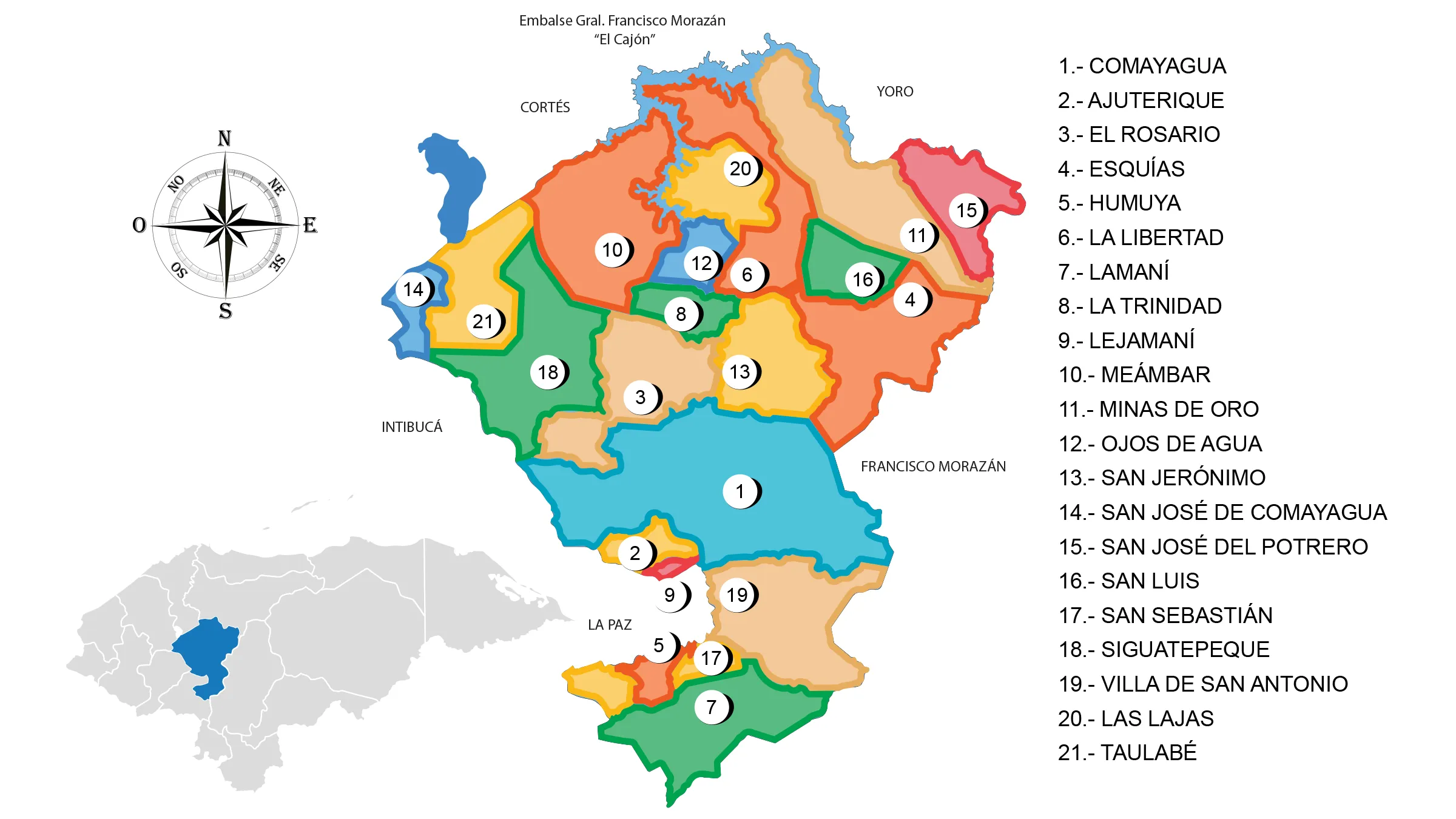
Department of Comayagua

Comayagua is one of the 18 departments that make up the Republic of Honduras.
View Map of Department of Comayagua
General Information
The department has a total area of 5,196 km² and, in 2005, had an estimated population of 390,643 people. It is also home to the Soto Cano Air Base, or «Palmerola,» a military base of the United States.
Origin of its name: Its name has two meanings; it was formerly known as «Páramo de agua» (Water Moorland), and in Mesoamerican language, it means «Place with comals» (a type of cooking tool).
Currently, the development of the Palmerola Commercial Airport is underway, and its opening is expected in late 2019. This project has helped to boost and revitalize the economy in the city and the surrounding areas near the airport.
The municipality of Comayagua is working diligently on a plan to modernize the city in order to accommodate the influx of visitors due to the growth of religious tourism, and with the upcoming opening of the airport, it is expected to further increase.
History of Comayagua
Its early inhabitants, like all those who arrived from the Asian continent, settled in places that provided food, water, forest resources, fauna, and other necessities to sustain the lives of organized groups in bands or tribes.
Spanish chroniclers, at the time of contact, located the inhabitants of the central region of Honduras within the geopolitical territoriality of Sulaco, Manianí. The struggles for the conquest of Honduran territory against the Spanish in the 1530s were resolved in favor of Francisco de Montejo, displacing Pedro de Alvarado by royal decision.
Don Alonso de Cáceres, representing Francisco Montejo, founded the town of Santa María del Valle de Comayagua on December 8, 1537. Later, it was subjected to fires and rebellions by the indigenous population. The process of conquest was completed by 1539 after subduing the indigenous people.
Due to the significance of this foundation, the Spanish crown decided to establish the headquarters of the Audiencia there. However, due to personal interests, it was installed in the city of Gracias, in the western part of the province.
Since 1560, the bishopric of Honduras was transferred to Valladolid in the Comayagua Valley. The government of Comayagua shared the governance of the province of Honduras with the mayor’s office of Tegucigalpa.
On September 28, the documents of Independence of Central America arrived, received by Intendant Gregorio Tinoco de Contreras, who rang the bell in the Plaza Mayor and cheered for the momentous event.
Throughout most of the colonial period, Comayagua was the most important political center of the province and even during the post-independence period. It ceased to be the capital on October 30, 1880, and was transferred to Tegucigalpa.
Municipalities of Comayagua
See List of Municipalities in Honduras.
- Comayagua 0301
- Ajuterique 0302
- El Rosario 0303
- Esquías 0304
- Humuya 0305
- La Libertad 0306
- Lamaní 0307
- La Trinidad 0308
- Lejamaní 0309
- Meámbar 0310
- Minas de Oro 0311
- Ojos de Agua 0312
- San Jerónimo 0313
- San José de Comayagua 0314
- San José del Potrero 0315
- San Luis 0316
- San Sebastián 0317
- Siguatepeque 0318
- Villa de San Antonio 0319
- Las Lajas 0320
- Taulabé 0321
Geography of Comayagua
Location: It is located in the central part of the country.
Boundaries:
- North: Departments of Cortés and Yoro;
- South: Departments of La Paz and Francisco Morazán;
- East: Department of Francisco Morazán;
- West: Departments of Intibucá and Santa Bárbara.
Important rivers: Humuya River and its tributaries, Selguapa, Yuré, Maragua, Guare, El Sulaco, and Jaitique.
Protected areas: Montecillos Biological Reserve; Azul Meámbar National Park, El Cajón, Taulabé Caves.
Lakes: Lake Yojoa.
Mountain ranges: Montecillos Mountains, Comayagua Mountains.
Economy of Comayagua
Coffee cultivation, vegetables, tomatoes, onions, basic grains, and soybeans; cattle, horse, and goat breeding; poultry farming; wood industry and its derivatives, food products; gold and silver mining.
Commerce: The main urban centers are Comayagua and Siguatepeque.
Fauna and Flora of Comayagua
Mammals: Shrew, squirrel, coati, opossum, skunk, raccoon, deer, agouti, peccary, coyote, fox, wildcat, pumas, ocelot, and jaguar.
Birds: Woodpecker, quetzal, pigeon, roadrunner, magpie, grackle, quail, turtle dove, parakeet, thrasher, goldfinch, and hawk.
Flora: Pine forests in the mountains.
Tourism in Comayagua
- Historic downtown of Comayagua with churches and government buildings
- Caxa Real, former Presidential Palace
- Hospital San Juan de Dios
- Tridentine College
- Bishop’s Headquarters
- Museums, archaeological sites
- El Cajón
- Lake Yojoa
- Taulabé Caves
Dams
In the northern part of Comayagua department, the Francisco Morazán hydroelectric dam, better known as «El Cajón,» is located. It generates a significant percentage of the country’s energy for development.
Comayagua served as the seat of the country’s main authorities for almost 300 years. Currently, it serves as a productive center for agriculture, livestock, and commerce.
It also houses the El Coyolar dam, which serves for the irrigation of crops in the Comayagua Valley.


