Department of the Bay Islands
The Bay Islands are an archipelago consisting of three main islands and several smaller ones in the Caribbean Sea: Roatán, Guanaja and Utila, also constituting one of the eighteen departments of the Republic of Honduras.
General Information
Origin of its name: Due to its location in the Caribbean Sea bay.
The second largest island is Guanaja Island, and the largest city is Guanaja. The third island is Utila Island, and the largest city is Utila, which is the most visited for diving activities.
The Bay Islands are surrounded by the crystal-clear waters of the transparent Atlantic Ocean, also in different shades of blue, where turquoise-colored waters are very common, they are more than perfect for enjoying them by swimming or diving or resting on the beach shore.
In addition to their natural biodiversity, they have jungles that cover all their territory where a great diversity of animals, birds, reptiles, fish, plants, trees, etc., live.
They also have several freshwater sources, waterfalls, rivers, vegetation grows both on land and in the water on the shores of the beaches and in the ocean, all kinds of fish, crustaceans and other marine fauna. The sand of their beaches is white, these islands have the entire Atlantic Ocean as a natural pool, free access for all inhabitants and visitors.
The white sand is natural on the beach, comfortable for walking, running, resting, driving, placing a chair or towel, and sunbathing for a while on the beach, it enhances the transparency of the water that bathes its beaches, it is also ideal for giving life to the fish and seaweeds that are born and live near most of the beaches.
The Bay Islands have an international cargo port in Roatán, as well as the Juan Manuel Gálvez International Airport, a terminal for airlines that travel to the mainland of Honduras and abroad.
- Departmental Capital: Roatán
- Area: 236 km²
- Administrative Code: 11
- Population: 22,062 inhabitants
- Established on: March 14, 1872
- Borders: An archipelago surrounded by the Caribbean Sea or the Antilles.
- Language: Spanish (84%) (the only official language), English (15%), other European languages (1%)
History of the Bay Islands
In the pre-Hispanic era, the current territory of the Bay Islands was inhabited by natives of the Caribbean, serving as a commercial bridge between the peoples of the mainland and other cultures.
This is inferred from the arrival of the Genoese Admiral Christopher Columbus on his fourth and last voyage in 1502, who describes the natives in his ship’s log as «peaceful traders from the mainland due to the varied products».
From that moment on, the Bay Islands were at the mercy of expeditions, whose objective was the capture of slaves. For some time these territories were occupied by the English, which is why the Spanish crown tried to recover them with negative results, as they were maintained until the end of the Colony. The English invaders managed to maintain a smuggling trade between the Islands and areas of La Mosquitia.
With the breakup of the Central American federation in 1842, England once again took over the Honduran territories: the Bay Islands and La Mosquitia. As a result of the clash in the area between the United States and England, the latter, through the Wide-Cruz treaty in 1859, returned the occupied territories to Honduras, recognizing England to return the Bay Islands and the region of La Mosquitia, one of the agreed points was to leave freedom of worship to its inhabitants.
Later, when Brigadier General José Santos Guardiola was the constitutional president of the republic, he peacefully incorporated La Mosquitia and the Bay Islands into the Honduran state, making them territorial jurisdiction and protection. On March 14, 1872, they were created as a department of Honduras, thus achieving the formation of the territory.
Since the mid-19th century, the planting, cutting, and selling of bananas brought about an economic boom, which led to the creation of the department on March 14, 1872, during the government of José María Medina.
Geography of the Bay Islands
Location: It is located in the Caribbean Sea or the Antilles (Insular department).
Borders
- The three islands are surrounded by several keys and the Caribbean Sea or the Antilles.
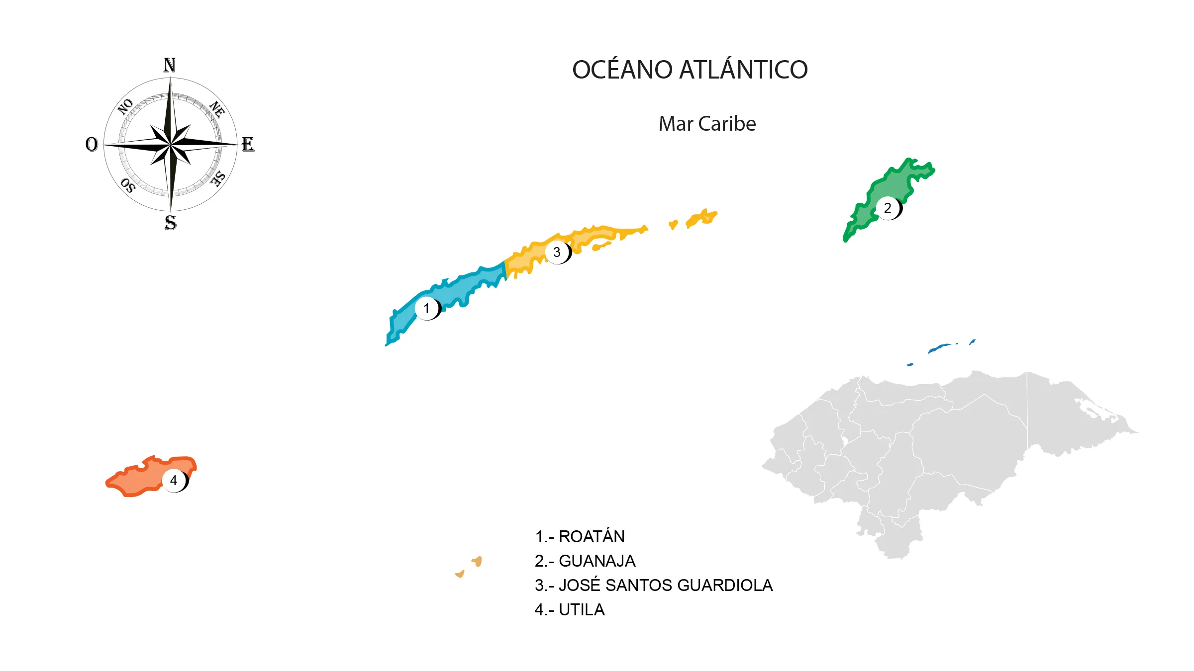
Municipalities of the Bay Islands
See List of Municipalities of Honduras
- Roatán (Cabecera departamental) 1101
- Guanaja 1102
- José Santos Guardiola 1103
- Utila 1104
Protected areas: Guanaja Coral Reef Marine National Park; West End marine sanctuary; Guanaja forest reserve; wildlife refuge, Utila Keys, Port Royal, Santa Elena; marine reserve, Barbareta, Sandy Bay, West End, Barbareta, Cochinos Keys, Zapotillos Keys, Turtle Harbor and Swan Island.
Islands: Roatán, Guanaja, Utila, Morat, Santa Elena, and Swan Island.
Keys: Zapotillo Keys and Cochinos Keys
Ranges: Extension of the Omoa range.
Mountains: Pumpkin Hill in Utila; Dixon Cove and Port Royal in Roatán; College Hill, Savannah Bight in Guanaja.
Fauna and Flora of the Bay Islands
Mammals: Shrew, squirrel, coati, guazalo, skunk, raccoon, deer, pacas, peccary, coyote, fox, and wildcat.
Birdlife: Woodpecker, ocote dove, roadrunner or dog soul, grackle, seagull, pelican, pigeon, parakeet, kingbird or cliff-guard, thrush, heron, hawk, bearded vulture, owl, and osprey.
Marine species: Crab, lobster, dolphin, whale shark, shrimp, crab, manta ray, and a wide variety of fish native to coral reefs.
Flora: Pine forests in Guanaja and mangrove forests in Roatán.
Economy of the Bay Islands
Trade: Roatán, Utila, French Harbor, and Guanaja.
Main Economic Activity: Tourism, shrimp and fishing.
Cultivation of coconut, banana, lemon, plantain, corn, avocado, banana, and mango; raising of cattle, equine, swine and goats; industry: tourism, shrimp processing and fishing.
The islands’ most popular attraction are their coral reefs. The abundance of coral reefs in the Bay Islands and the rest of Honduras makes it the second country in the world with the most coral reefs, after Australia, where thousands of tourists come to dive each year.
The islands are also famous for their white sandy beaches, the native species of the archipelago, and those in transit, such as the famous whale shark.
The Bay Islands have hotel centers to accommodate domestic or foreign tourists, which contributes to being the most important source of income. In addition, its inhabitants engage in fishing and shrimp farming activities.
Tourism in the Bay Islands
The entire department is a tourist attraction due to its natural beauty, but among all, the most visited are the beaches, coral reefs, museums, aquariums, and Cochinos Keys.