Department of Olancho
Olancho is the largest department of the 18 departments that make up the Republic of Honduras.
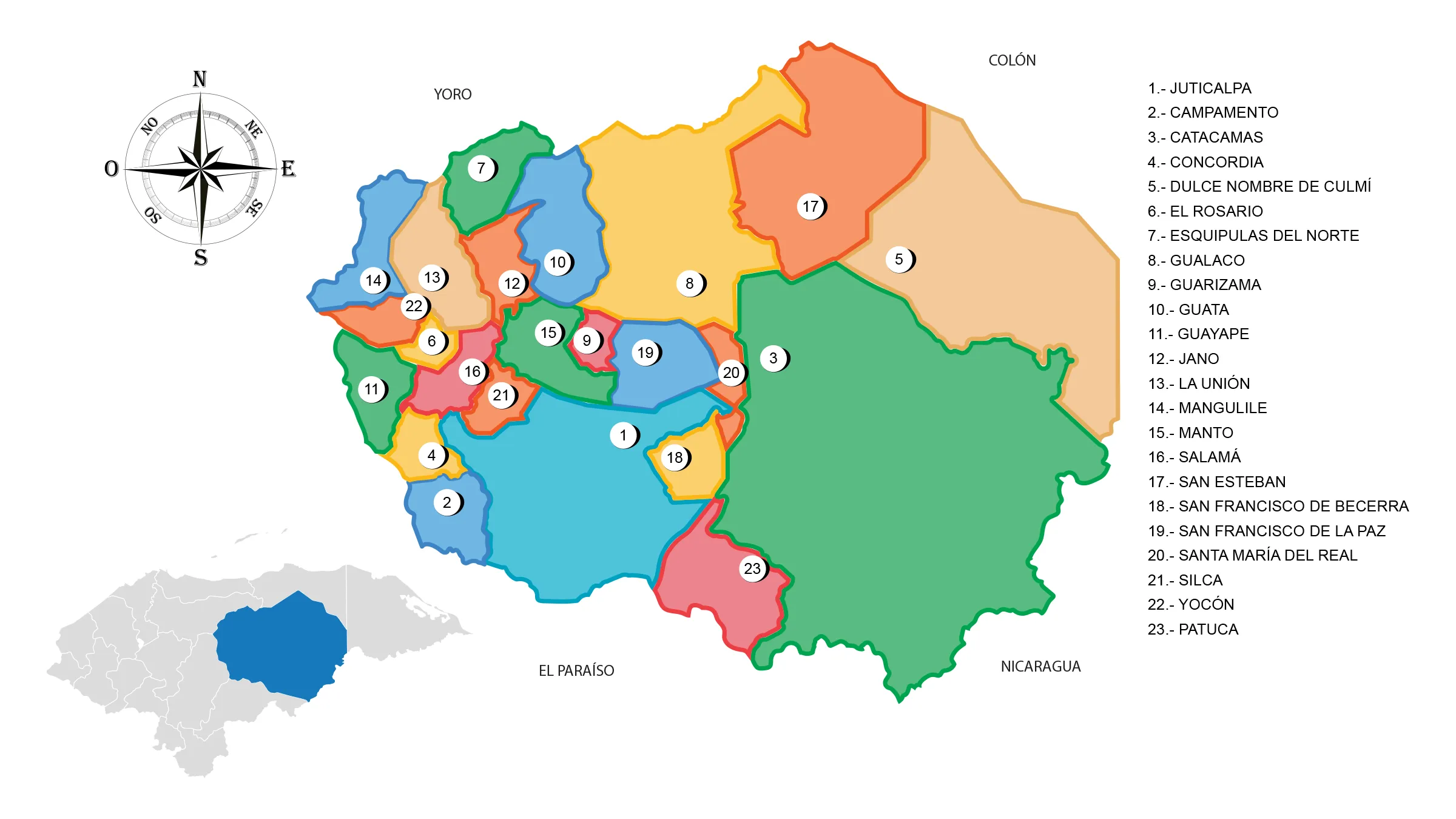
View Map of Department of Olancho
General Information about Olancho
Its territorial extension is larger than the neighboring republics of El Salvador and Belize, making it the second-largest subnational entity in Central America in terms of territory after Petén in Guatemala. This department was created on June 28, 1825.
Origin of its name: In Mesoamerican language it means «in the land of rubber».
In the year 1869, the territory of Olancho was reduced, as the municipality of Danlí became part of the department of El Paraíso.
- Departmental capital: Juticalpa
- Land area: 23,905 km2
- Administrative code: 15
- Population: 530,644 inhabitants (2012)
- Population density: 22 hab/km2
- Creation date: June 28, 1825
History of Olancho
The region has countless archaeological sites, with the one in Talgua standing out. Its antiquity dates back to 1000 BC, housing the oldest bone remains that evidence the presence of the first inhabitants of the region. At the time of contact, these territories were part of the geopolitical unit called the province of Olancho, bordering the Taguzgalpa region, with many shared cultural characteristics.
The territory of Olancho became a very autonomous region due to mining activity, which consisted of washing gold in the Guayape and Guayambre rivers. The rise of the main economic activity was manifested with the growth of cattle herding, combined with subsistence agricultural production during the Colonial era.
Since the 17th century, it was known as the district of Olancho. In ecclesiastical matters, the region is called the curate of Manto. At the end of the 18th century, Honduras became an intendency and Olancho a sub-delegation. On June 25, 1825, in the first territorial division of the state of Honduras, Olancho obtained departmental status.
For a long time, Olancho was the richest region of Honduras due to its cattle production. This provided it with great commercial and political influence within the government of the republic.
Because of this commercial influence; occasionally in the department, political struggles occurred. On December 7, 1864, the arrest of a congressman named Rosales caused a rebellion against the highest authorities of the department and the central government.
Lead by Colonels Barahona, Zavala, and Antúnez, more than a thousand rebels marched towards Tegucigalpa in 1865. Faced with this situation, the then President of the Republic, General José María Medina, organized a military expedition and led it himself, to counter the rebels.
At the end of the confrontation, Medina and his men prevailed over the rebels, capturing the ringleaders who were shot, beheaded, and buried. Several of the towns and villages of the department were set on fire and their inhabitants, many of them rebels, were shot or killed in combat.
After this event, there were many deportations and a massive exodus of Olanchanos to other parts of the country, leaving the department with a diminished population. Manto lost its title of departmental capital, which was transferred to Juticalpa.
Three years later, in 1868, the young man Serapio Romero, known as Cinchonero, rose up in Juticalpa along with a group of men against the mayor of the square, Nazario Garay. Both men had a machete duel, with Serapio Romero ending up victorious.
Then, defying the central government, the ‘Cinchonero’ unearthed the heads of Colonels Barahona, Antúnez, and Zavala and paid them a posthumous tribute. To this new rebellion, the government responded by sending a military contingent, who ended up victorious, capturing and beheading Serapio Romero. After these bloody events, Olancho became an almost depopulated and therefore, quiet department.
Geography of Olancho
Olancho is located in the northeastern part of the country. It borders the departments of Yoro and Colón to the north; to the south with El Paraíso and the Republic of Nicaragua; to the east with the Department of Gracias a Dios and to the west with the departments of Francisco Morazán and Yoro.
Boundaries
- North: Departments of Yoro and Colón
- South: Department of El Paraíso and Republic of Nicaragua
- East: Department of Gracias a Dios and Republic of Nicaragua
- West: Departments of El Paraíso and Francisco Morazán.
It has an area of 23,905 km², which in terms of extent is similar to that of the island of Sardinia. It extends between 14o 03′ and 15o 35′ north latitude and 85o 00′ and 86o 59′ west longitude.
The population of Olancho is approximately 500,000 people with a density of 18.1 inhabitants per km².
Municipalities of Olancho
The department is made up of 23 municipalities. Juticalpa is its departmental capital and Catacamas is the second most important city.
See List of Municipalities of Honduras
- Juticalpa 1501
- Campamento 1502
- Catacamas 1503
- Concordia 1504
- Dulce Nombre de Culmí 1505
- El Rosario 1506
- Esquipulas del Norte 1507
- Gualaco 1508
- Guarizama 1509
- Guata 1510
- Guayape 1511
- Jano 1512
- La Unión 1513
- Mangulile 1514
- Manto 1515
- Salamá 1516
- San Esteban 1517
- San Francisco de Becerra 1518
- San Francisco de la Paz 1519
- Santa María del Real 1520
- Silca 1521
- Yocón 1522
- Patuca 1523
The geography of Olancho is composed of a series of mountain ranges that are part of the Central American Cordillera.
Valleys: Guayape, Catacamas, Lepaguare, Agalpa, Patuca.
Rivers: Guayape, Patuca and Tinto or Negro.
Sierras: La Esperanza, Agalta, Punta Piedra and Entre Ríos.
Mountains: Cerro Azul, Botaderos, Macupina, Liquidambar, Los Tembladeros, Fray Pedro, Agua Blanca del Boquerón, Babilonia de Malacate, Patuca and Colón.
Communication Route
Olancho is connected by land with the rest of the country via the main road that starts from the city of Juticalpa heading to Tegucigalpa. This journey is approximately 170 km.
In addition to this road, Olancho is connected to the north coast of Honduras through the road that leads to the municipality of San Esteban. This continues through Bonito Oriental until it reaches the road that connects the city of Trujillo with the port of La Ceiba.
There is also land communication between the municipality of La Unión and Olanchito, department of Yoro.
Economy of Olancho
Trade: Juticalpa, Catacamas and Campamento.
Olancho’s economy is based on agriculture and livestock. Among the agricultural products stand out: corn, sugar cane, coffee, sorghum, beans, rice, coyol, among others. Also part of the Olancho economy are: wood and tobacco.
Production: Coffee, cassava, tomato, watermelon, corn, beans, sorghum, rice and soybeans.
Breeding: cattle, equine, swine and goats.
Mines: gold, silver, zinc, copper, lead and antimony.
Olancho’s Fauna and Flora
Mammals: shrew, squirrel, coati, guazalo, skunk, raccoon, deer, paca, tapir or danto, peccary, coyote, fox, wildcat, puma, ocelot and jaguar.
Avifauna: woodpecker, grouse, ocotera dove, roadrunner or dog soul, magpie, zanate, quail, torcasa, parakeet, parrot, macaw, quetzal, taragón or guardabarranco, mockingbird, goldfinch, hawk, vulture, owl and eagle.
Flora: Forests of pine, oak, mahogany, ceiba and broadleaf.
Tourism in Olancho
- Kaha Kamasa – also known as the White City
- Part of the Río Plátano Biosphere Reserve is located in Olancho territory.
- National Parks of:
- Patuca,
- Sierra de Agalta
- La Muralla
- Talgua Caves (Catacamas)
- El Boquerón


