Department of Choluteca
Choluteca is one of the 18 departments into which Honduras is divided, and the southernmost of this country.
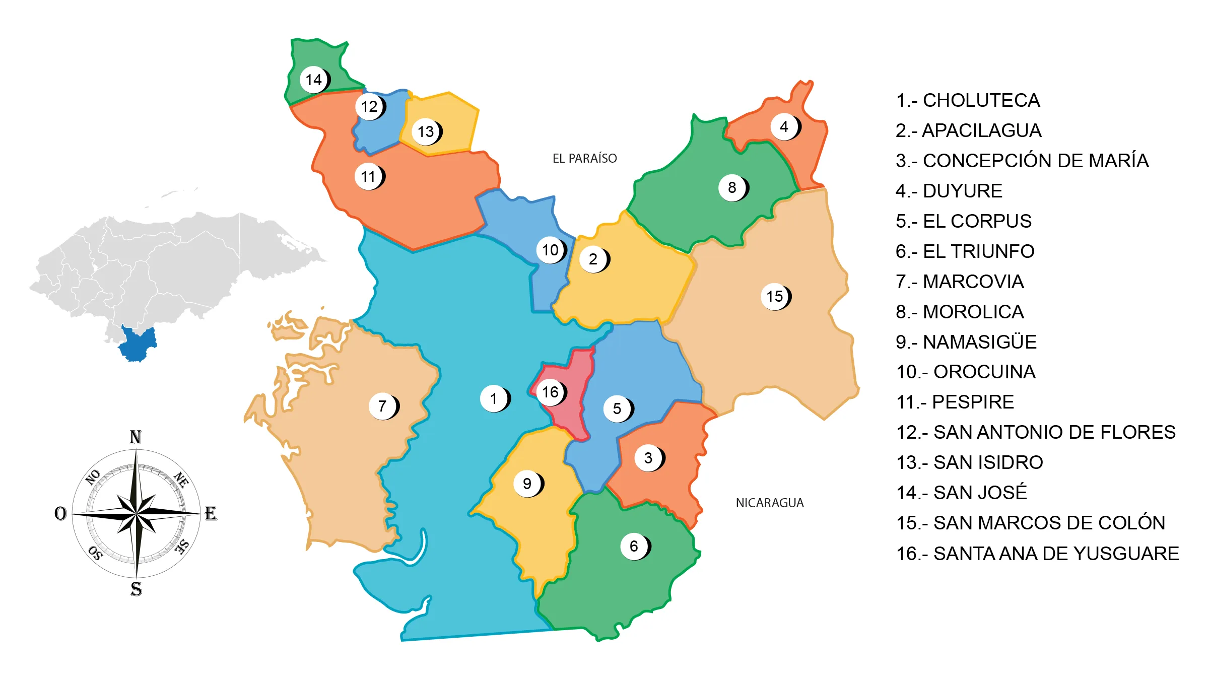
View Map of Department of Choluteca
General Information
Origin of its name: Its name derives from the gentilic Cholollan, native to Mesoamerica, now known as Cholula.
- Departmental capital: Choluteca
- Territorial area: 4360 km2
- Administrative code: 06
- Population: 475,144 inhabitants (2012)
- Population density: 107 people/km2
- Date of creation: June 28, 1825
History of Choluteca
Choluteca was one of the original seven departments into which Honduras was divided after its independence in 1825. However, its borders have changed throughout history. In 1843, the Guascorán district, previously part of Comayagua, was added to its territory. In 1893, its westernmost part was separated, creating the department of Valle.
The ethnic groups that populated the current department of Choluteca were the Chorotegas, perhaps one of the last waves of immigrants from northern Mesoamerica.
At the time of contact in the southern zone, for some specialists, there was the geopolitical territoriality of Choluteca Malalaca, as a lordship or chieftaincy. It was Andrés Niño in 1523 who explored the Gulf of Chorotega, sent by Pedro Arias de Avila from Darien and named it «Gulf of Fonseca» in honor of the President of the Council of the Indies, Juan Rodríguez de Fonseca.
In the advance of the New Spain (Mexico) current in the conquest of Honduras, it was Juan de la Cueva, a soldier of Pedro de Alvarado, who founded the city of Choluteca in 1534, turning it into an administrative center for rich minerals such as silver and gold found in the area, as well as a strategic commercial point between El Salvador and Guatemala.
During the colonial period, it was considered one of the districts of the Province of Honduras. When the first territorial division of the State took place in 1824, it became one of the seven departments. Due to its geographical position and its proximity to the Republic of Nicaragua, in the 1940s, the Pan-American Highway and the Choluteca Bridge were constructed.
The city of Choluteca was the birthplace of the wise José Cecilio del Valle, the drafter of the Act of Independence of Central America. The fellow countrymen of the wise Valle are proud of his legacy, as evidenced by the historical and cultural value of the heritage represented by the house where he was born and lived.
Geography of Choluteca
Location: It is located in the southern part of the country.
Boundaries
- North: Departments of Francisco Morazán and El Paraíso
- South: Republic of Nicaragua and the Gulf of Fonseca
- East: Republic of Nicaragua
- West: Department of Valle and the Gulf of Fonseca
Choluteca is located in the south of Honduras. It has a total area of 4360 km2 and a population of approximately 395,000 inhabitants. The region has vast areas used for agriculture, fishing, sugar production, shrimp farming, among others. The departmental capital is the city of Choluteca, which is crossed by the Choluteca River. To reach the city, one must pass through the Choluteca Bridge.
In recent years, Choluteca has developed its infrastructure, with several hotels and diverse amenities for both its residents and visitors.
It shares borders with the departments of Francisco Morazán and El Paraíso to the north, the Gulf of Fonseca and the department of Valle to the west, and the neighboring nation of Nicaragua to the east and south.
Important rivers: Choluteca, Texiguat, Orocuina, El Sampile Namasigüe, Negro, Guasaule, and San Marcos or Comalí.
Protected areas: Bahía de San Lorenzo, Cerro Guanacaure, El Jicarito, La Berbería, La Botija, Las Iguanas, Los Delgaditos, San Bernardo.
Mountain ranges: Dipilto foothills, in the eastern part of the department.
Mountains: Colón, San Marcos, and La Botija.
Municipalities of Choluteca
See List of Municipalities in Honduras
- Choluteca cabecera departamental 0601
- Apacilagua 0602
- Concepción de María 0603
- Duyure 0604
- El Corpus 0605
- El Triunfo 0606
- Marcovia 0607
- Morolica 0608
- Namasigüe 0609
- Orocuina 0610
- Pespire 0611
- San Antonio de Flores 0612
- San Isidro 0613
- San José 0614
- San Marcos de Colón 0615
- Santa Ana de Yusguare 0616
Fauna and Flora of Choluteca
Mammals: Shrew, squirrel, coati, tayra, skunk, raccoon, deer, agouti, peccary, coyote, fox, bobcat, puma, ocelot, and jaguar. Avifauna: woodpecker, resplendent quetzal, white-tailed hawk, roadrunner, magpie, great-tailed grackle, quail, common ground dove, parakeet, turquoise-browed motmot, yellow warbler, goldfinch, hawk, vulture, owl, heron, pelican, and osprey. Marine species: crab, shrimp, crab, curil, manta ray, and a variety of fish.
Flora: Mangrove forests, ceiba trees, amates, gourd trees, laurel, guanacaste, and tamarind.
Economy of Choluteca
Commerce: Choluteca, San Marcos de Colón, Pespire, and El Triunfo.
Main economic activity: cultivation of sugarcane, melon, watermelon, millet, corn, mango, and forage sorghum; raising of cattle, horses, pigs, and goats; industry: food products, beverages, tobacco, wood, and dairy derivatives.
Tourism in Choluteca
- Historic city center
- Beaches of Cedeño and Punta Ratón


