Department of Francisco Morazan

The department of Francisco Morazán is one of the seven original departments of the Republic of Honduras.
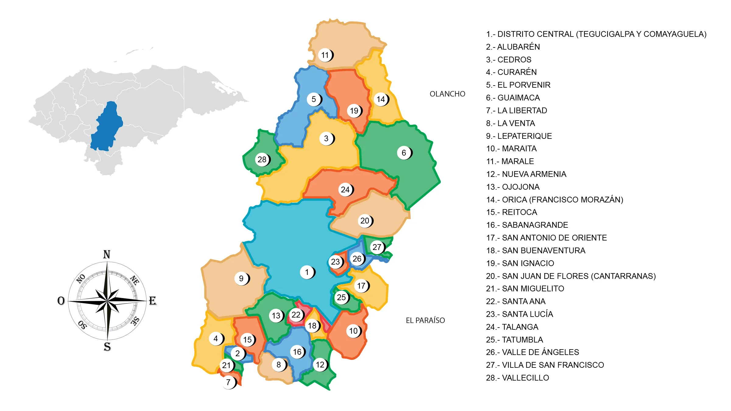
View Map of Department of Francisco Morazan
General Information
It was founded by decree of the first Constituent Assembly of the State, issued on June 28, 1825, during the administration of Dionisio de Herrera.
It began to be called Francisco Morazán on January 11, 1943.
Origin of its name: In honor of the Central American hero Francisco Morazán (1792-1842).
- Date of creation: June 28, 1825
- Departmental capital: Municipality of the Central District (Composed of the cities of Comayaguela and Tegucigalpa, which is also the current capital of the Republic of Honduras)
- Land area: 8,580 km2
- Population: 1,553,379 643 inhabitants (2012)
- Population density: 181.04 hab./km2
- Administrative code: 08
- Municipalities: 28
- Aldeas: 274
History of Francisco Morazán
Mining activity was the main reason for the establishment of the Spaniards in the area. The native people of the indigenous village of Tegucigalpa, probably of Lenca origin, were located in the indigenous province of Sulaco called Manianí. Apparently, September 29, 1578, is the date of the arrival of the Spaniards, and it was later named Real de Minas de Tegucigalpa, Alcaldía Mayor de Tegucigalpa, Villa de Tegucigalpa or San Miguel de Heredia during the colonial period.
It was an important mining and commercial center in the province of Comayagua. In the last years of the Colonial period, it was part of the Intendancy of Comayagua until 1812, when it became the Alcaldía Mayor again. Within its borders, the greatest Honduran hero, José Francisco Morazán, was born, who inspired the dream of Central American unity.
The department was created on June 28, 1825, according to the first constitution of the State of Honduras in that same year. On January 11, 1943, President Tiburcio Carias Andino changed its name to Francisco Morazán. The city was designated as the capital of the State of Honduras on October 30, 1880, by President Marco Aurelio Soto. Since then, it has become the political center where the three branches of the State—the Executive, Legislative, and Judicial—reside. It is also an important center for commercial and industrial development in the country.
In 1869, the department was reduced when the municipality of Texiguat was annexed to the department of El Paraíso. In 1943, Tegucigalpa was renamed ‘Francisco Morazán’ to commemorate the centennial of the death of the Paladin of Central American Unity, while dictator Tiburcio Carias Andino was in power.
Geography of Francisco Morazán
Location: It is situated in the central part of the country. With a territorial extension of 8,619 km, Francisco Morazán is located in the center of the country.
View on Google Maps
Boundaries
- North: departments of Comayagua, Yoro, and Olancho
- South: departments of Valle and Choluteca
- East: departments of Olancho and El Paraíso
- West: departments of Comayagua and La Paz
Municipalities of Francisco Morazán
See List of Municipalities of Honduras
- Distrito Central (Tegucigalpa y Comayaguela) 0801
- Alubarén 0802
- Cedros 0803
- Curarén 0804
- El Porvenir 0805
- Guaimaca 0806
- La Libertad 0807
- La Venta 0808
- Lepaterique 0809
- Maraita 0810
- Marale 0811
- Nueva Armenia 0812
- Ojojona 0813
- Orica (Francisco Morazan) 0814
- Reitoca 0815
- Sabanagrande 0816
- San Antonio de Oriente 0817
- San Buenaventura 0818
- San Ignacio 0819
- San Juan de Flores o como se le conoce Cantarranas 0820
- San Miguelito 0821
- Santa Ana 0822
- Santa Lucía 0823
- Talanga 0824
- Tatumbla 0825
- Valle de Ángeles 0826
- Villa de San Francisco 0827
- Vallecillo 0828
Important Rivers
Talanga, Playos, Guarabuquí or Guayape, Choluteca, Zamorano, Jalán del Hombre.
Protected Areas
- La Tigra National Park and Montaña de la Flor;
- Corralito Wildlife Refuge;
- Carias Bermúdez Multiple Use Reserve;
- Cerro Uyuca, Yerba Buena, Sierra Misoco, and El Chile Biological Reserves;
- Montaña de la Flor Forest Reserve;
- Ayasta Petroglyphs Cultural Monument.
Mountain Ranges: Comayagua, Sulaco, Misoco, Lepaterique.
Mountains: Yerbabuena, Upare, Azacualpa, Cantagallo, Uparito, Santiponce, Curarén, Sinigua, Cerro de Hule, San Juancito, Montañita, El Chile.
Fauna and Flora
Mammals: shrew, squirrel, coati, agouti, skunk, raccoon, deer, paca, peccary, coyote, fox, wildcat, puma, ocelot, and jaguar. Avifauna: woodpecker, chestnut-headed oropendola, ocotero pigeon, roadrunner, magpie, great-tailed grackle, quail, pigeon, parakeet, turquoise-browed motmot, cenzonde, goldfinch, and hawk.
Flora: pine forests, oak forests, liquidambar forests, and evergreen trees.
Economy
The economy of Francisco Morazán is based on commerce, hotels, and restaurants, which account for 24% of the economy. Other significant sectors include non-metallic minerals, chemicals, machinery and equipment, paper and printing products, food and beverages, tobacco, wood derivatives, textiles and clothing. The communal services sector contributes 21% to the economy, while agriculture represents 13% and includes the cultivation of sugarcane, mango, orange, potato, onion, cabbage, tomato, watermelon, cantaloupe, tobacco, corn, beans, and sorghum. Livestock farming, including cattle, horses, and pigs, is also an important agricultural activity.
- Commerce: Tegucigalpa, Talanga, Guaimaca.
- Mines: Copper, lead, silver, gold, zinc, iron, and mercury deposits.
Tourism
- Historic Center of Tegucigalpa
- United Nations Park or El Picacho
- La Tigra National Park
- Valle de Ángeles
- San Juancito
- Santa Lucía
- Ojojona
- El Uyuca
- El Zamorano


