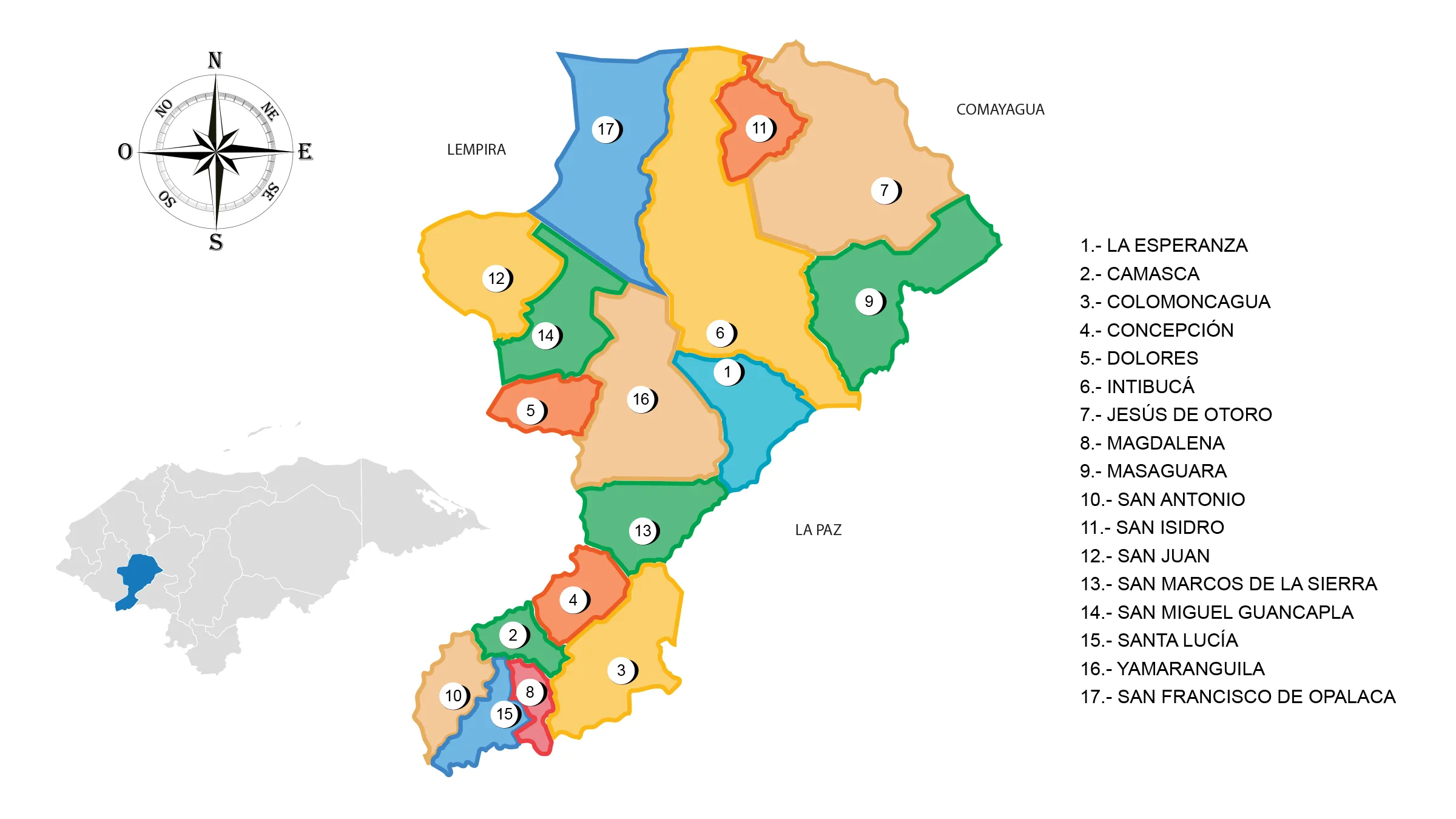
Department of Intibuca
Intibucá is one of the 18 departments of the Republic of Honduras, located in the western part.

General Information
Origin of its name: Indigenous.
On March 7, 1883, Decree No. 10 was issued, in which the circle of La Esperanza requested the creation of a new department. In April of that same year, the Decree creating the department of Intibucá was issued, also taking part of La Paz.
- Departmental capital: La Esperanza
- Territorial area: 3123 km2
- Population: 245,439 inhabitants (2012)
- Population density: 79 inhabitants/km2
- Creation date: April 16, 1883
History of Intibucá
The primitive inhabitants of Intibucá were of Lenca origin, which was the most numerous and extensive group in the west of the country. They faced the Spanish conquest process, being subjugated and forced to leave the best cultivation lands. This forced them to take refuge in the highlands. However, they managed to adapt products such as potato, grape, peach, and strawberry to this type of land and climate.
Its existence as a department dates back to the 19th century when the political governor José María Cacho drew a map of the west of Honduras, using it to divide this vast region into several departments.
Creation date: April 16, 1883. The creation of this department was due to a report presented in 1869 by the Political Governor of the department of Gracias, José María Cacho, who pointed out the convenience of dividing the latter due to its vast extent, which constituted an obstacle to its good governance.
Geography of Intibucá
Location: It is located in the western part of the country.
Boundaries
- North: Department of Comayagua, Lempira and Santa Bárbara.
- South: Republic of El Salvador.
- East: Department of Comayagua and La Paz.
- West: Department of Lempira.
Municipalities of Intibucá
See List of Municipalities of Honduras
- La Esperanza 1001
- Camasca 1002
- Colomoncagua 1003
- Concepción 1004
- Dolores 1005
- Intibucá 1006
- Jesús de Otoro 1007
- Magdalena1008
- Masaguara 1009
- San Antonio 1010
- San Isidro 1011
- San Juan 1012
- San Marcos de la Sierra 1013
- San Miguel Guancapla 1014
- Santa Lucía 1015
- Yamaranguila 1016
- San Francisco de Opalaca 1017
Valleys: Otoro Valley, 30 km long by 8 km wide.
Mountains: Opalaca Range, which has several branches and enters the department of La Paz. Montecillos Range is a chain of mountains that serves as a boundary with the department of Comayagua, there are also the mountains of Opatoro, Concepción, El Picacho, Goascotoro, El Granadino and others.
Rivers: Intibucá River that passes through La Esperanza, San Juan River; Otoro River, a tributary of the Ulúa, waters the valley of its name. The Negro River serves as a dividing line with the department of Lempira known by the name of Guarajambala; Torola River and Gualcarque River, which flows into the Lempa River.
Protected Areas
- Mixcure Wildlife Refuge
- Toco River Natural Monument
- Opalaca Biological Reserve.
Tourism in Intibucá
- Rock shelter – the Giant’s Cave
- Chiligatoro Lagoon
- Beaches of the Ulúa River
- Guancasco dances and historic helmets of some municipalities.