Department of Copan
Copán is one of the eighteen departments that make up the Republic of Honduras, border with Guatemala.
General Information
Origin of its name: Copán, according to some specialists, means «Wooden Bridge» or what is called «Copante» in the local language.
For many years, Copán has been famous for its magnificent Mayan ruins, which led to its inclusion in UNESCO’s World Heritage List in 1980.
Discovered in 1570 by Diego García de Palacio, the ruins of Copán – one of the most important sites of the Mayan civilization – were only excavated in the 19th century.
The remnants of the citadel and the impressive public squares are examples of the three main stages of development of this city before it was abandoned in the early 10th century.
Departmental Capital: Santa Rosa de Copán.
Territorial Surface: 3242 km2
Population: 377,179 inhabitants (2012)
Population Density: 116 hab/km2
Date of Creation: May 28, 1869.
History of Copán
The original inhabitants of the department were the Maya and Chortí people, organized in tribes and chiefdoms. The Maya founded the city of Copán on the banks of the Copán River, in a valley with very fertile land. The alliance of the Maya with a Chortí lordship led to the development of an extremely important culture during the Pre-Hispanic era in Honduras.
The founder of the Maya lineage of Copán was Yax Kuk Mo, who, along with 15 successive rulers, achieved considerable advancements in the fields of science, arts, and philosophy. This legacy has transcended the borders of time and culture, deserving the recognition bestowed upon it by UNESCO in 1980 when it was declared a World Heritage Site.
During the Federal Republic of 1823-1839, José Justo Milla, the vice president of the Federation, invaded Honduras under the pretext of protecting the tobacco production in Santa Rosa de Copán. In the first territorial division of the state of Honduras in 1824, the current territory of Copán, then called Santa Rosa, became a parish attached to the department of Gracias. The department was created on May 28, 1869, along with La Paz and El Paraíso.
Geography of Copán
Location: It is located in the western part of the country.
Boundaries
- North: Republic of Guatemala
- South: Department of Ocotepeque
- East: Departments of Santa Bárbara and Lempira
- West: Republic of Guatemala
Major rivers: Copán, Chamelecón, Jicatuyo, and Higuito.
Protected areas: Cerro Azul National Park; Puca Wildlife Refuge.
Mountain ranges: Merendón and Espíritu Santo.
Mountains: Gallinero
Transportation
- The international highway or Pan-American Highway runs through the entire department with asphalted highways. There are heliports in the cities of Santa Rosa de Copán, Cucuyagua, and Copán Ruinas.
- The department has national television and radio signals, as well as signals from private companies and local radio stations. There is circulation of newspapers and magazines.
- Currently, a paving project is being carried out.
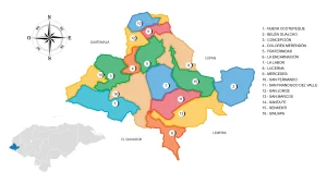
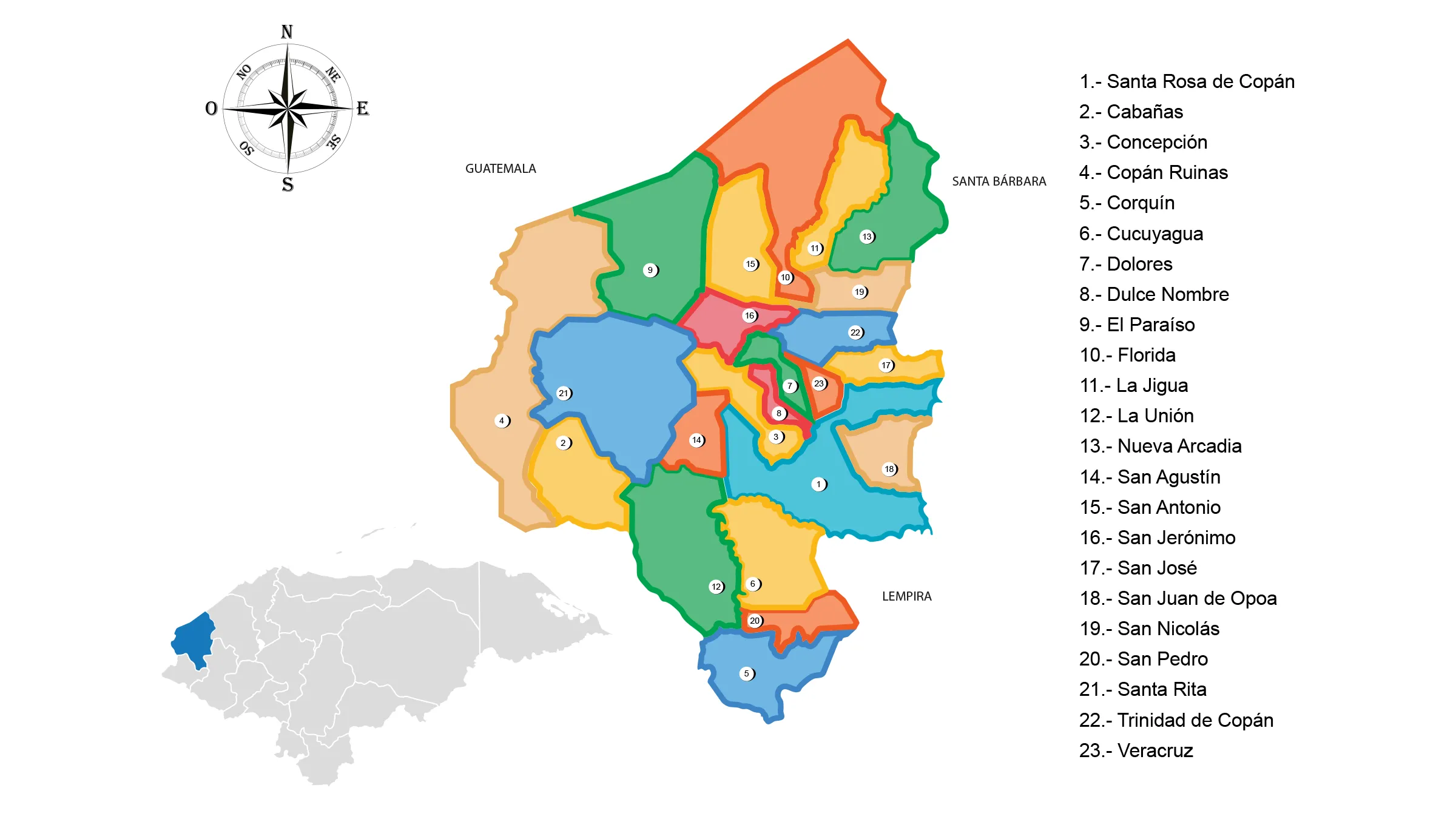
Municipalities of Copán
See List of Municipalities of Honduras
- Santa Rosa de Copán 0401
- Cabañas 0402
- Concepción 0403
- Copán Ruinas 0404
- Corquín 0405
- Cucuyagua 0406
- Dolores 0407
- Dulce Nombre 0408
- El Paraíso 0409
- Florida 0410
- La Jigua 0411
- La Unión 0412
- Nueva Arcadia 0413
- San Agustín 0414
- San Antonio 0415
- San Jerónimo 0416
- San José 0417
- San Juan de Opoa 0418
- San Nicolás 0419
- San Pedro 0420
- Santa Rita 0421
- Trinidad de Copán 0422
- Veracruz 0423
Fauna and Flora of Copán
Mammals: Shrew, squirrel, coati, agouti, skunk, raccoon, deer, agouti, peccary, coyote, fox, bobcat, puma, ocelot, and jaguar.
Birds: Woodpecker, rufous sabrewing, white-winged dove, roadrunner, magpies, great-tailed grackle, quail, common ground dove, parrot, parakeet, scarlet macaw, emerald toucanet, goldfinch, thrush, great-tailed grackle, hawk, bearded vulture, owl, and osprey.
Flora: Pine forests, mahogany, San Juan wood, cedar, cablote, and silver fir.
Economy of Copán
The Department of Copán is a geographically mountainous area. Its main source of income comes from tourism to the Mayan archaeological sites, followed by coffee cultivation and production, livestock farming, vegetable and staple crop agriculture, leather goods production, industrial products, etc.
Production: Coffee, tobacco, watermelon, staple crops, and sugarcane cultivation; cattle, horse, and pig farming; garment industry, leather goods, food products, and beverages.
Commerce: Santa Rosa de Copán and La Entrada.
Mines: San Andrés Mines, which extract gold, silver, antimony, copper, and nickel.
Tourism in Copán
- Historic downtown of Santa Rosa
- Zorosco Waterfalls
- Belén
- Los Ángeles
- La Entrada, El Paraíso
- Archaeological Park of Copán Ruins and El Puente
- Hot Springs
Mayan Ruins in Copán
In the department of Copán, there is an important Mayan city with an unknown name. It was a prominent ceremonial center and one of the main scientific centers of the Classic Maya period, used as an astronomical observatory. It is located 1.5 kilometers from the town of Copán Ruinas, between La Laguna and Barbasqueadero, 12 km east of the Guatemala border.
Copán is one of the most impressive Mayan archaeological sites that have been discovered. It was discovered in the Motagua River basin in 1570 by Diego García de Palacio. It was baptized as the «Athens of the Mayan world» due to its archaeological similarity to that classical city.
The Maya were one of the five ancient civilizations that created a written language. And although the number of people who understand Mayan hieroglyphs has diminished over the centuries, the evidence of this language remains as strong as ever. Perhaps one of the best examples of Mayan hieroglyphs is found within the archaeological park of Copán. In 749 AD, King Smoke Shell built a hieroglyphic staircase. This immense task was designated to perpetuate the success of the Mayan kingdom. It is the longest inscription found in the Mayan world, with 1,250 blocks of hieroglyphs documenting the life of the king and the people of that time. The Hieroglyphic Staircase is probably the most famous monument in the archaeological city.
It is estimated that the Copán Valley was inhabited from around 1200 BC, although there was no royal family in power until after 426 AD. It is believed that at its peak, it was home to over 20,000 inhabitants.
This Mayan land is known for its meticulously constructed magnificent buildings and architecture that leave no doubt about the rich, intelligent, and advanced culture of this ancient civilization. The people of the area demonstrated outstanding knowledge and skill in the areas of sculpture, astronomy, writing, and the use of hieroglyphs.