Political and Administrative Division of Honduras – Departments and Municipalities
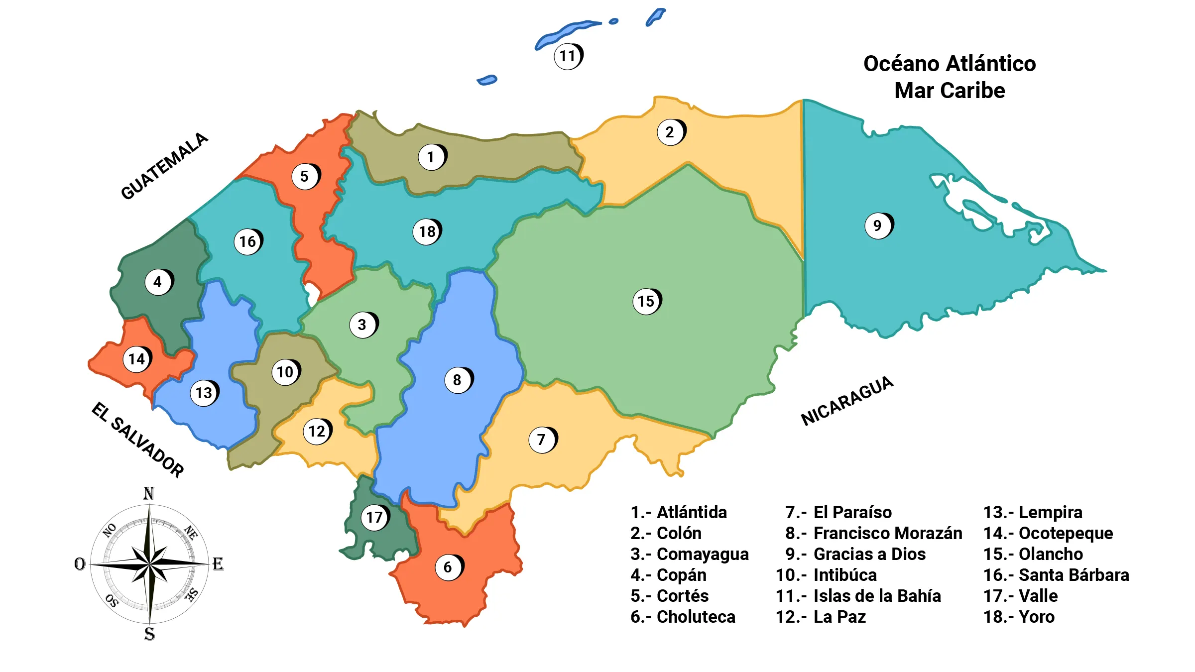
Honduras is politically and administratively organized into 18 departments, 298 municipalities, 3,731 villages, and 30,591 hamlets.
Each department is governed by a Departmental Governor, who is currently appointed by the President of Honduras. The authority of the municipality resides in the Mayor and Vice-Mayor, along with their councilors.
Departmental Authorities
Role of the Departmental Governor
Although their role is mostly ceremonial, they have functions such as representing the President of the Republic in specific programs related to health, education, agriculture, among others, in their jurisdictions, and presiding over working groups in other fields.
The requirements to be a Departmental Governor are: Reside continuously in the department for more than 5 years and meet the same requirements as those to be a Mayor.
Starting from the upcoming elections in 2020, it is expected that they will be elected by popular vote, and each political party will present a candidate.
Role of the Mayor and Vice-Mayor
Municipalities are governed by the Mayor and Vice-Mayor, along with a group of councilors, who are elected by popular vote in the presidential elections for a term of 4 years.
Among the mayoral candidates of each political party, the winner is the one who receives the most votes, and the subsequent candidates become councilors. The councilors form part of the Municipal Corporation, assisting the elected mayor in decision-making within the municipality and assuming responsibilities specific to their position.
The requirements to be a Mayor are: Be a Honduran citizen, be born or have resided in the municipality continuously for more than 5 years, be over 18 years old, and be able to read and write.
Mayors have the privilege of being reelected indefinitely by popular will.
AMHON
Currently, Mayors are organized through the Association of Municipalities of Honduras (AMHON) https://www.amhon.hn/
It is a civil entity, nationally representative, non-profit, and non-partisan, with full capacity to exercise rights, incur obligations, and intervene in legal proceedings with its own assets and independent administration. It consists of the 298 mayors of the country, representing their municipalities.
AMHON was established on April 11, 1962, by Resolution No. 16-1962, as ordered by the Ministry of Governance and Justice under the presidency of Ramón Villeda Morales. In 1963, its statutes were reformed to give the law and the institution the agility required by changes in municipal government.
Atlántida Department
Located in the northern sector of Honduras, the economic activity of the Atlántida department is based on agriculture, livestock, trade, and tourism.
This department presents two distinct physiographic regions, one flat and the other mountainous. The first extends along the Caribbean coast, forming wide and attractive beaches, with the notable coastal territory of Tela Bay.
It borders the Caribbean Sea to the north, where the department of Bay Islands is located, Yoro department to the south, Colón department to the east, and Cortés department to the west.
General Information about Atlántida
- Date of creation: February 24, 1902
- Departmental capital: La Ceiba
- Territorial area: 4,227 km2
- Administrative code: 01
- Municipalities: 8
- Villages: 176
- Hamlets: 552
Population of Atlántida
- Total population (2018): 471,575
- Population in rural areas: 157,611
- Population in urban areas: 313,964
- Life expectancy (in years): 75.4
- Infant mortality rate: 19.7
Municipalities of Atlántida
- La Ceiba (Municipal seat) 0101
- El Porvenir 0102
- Esparta 0103
- Jutiapa 0104
- La Masica 0105
- San Francisco 0106
- Tela 0107
- Arizona 0108
Department of Colón
Its name comes from the historical fact that it was the first mainland in Central America stepped on by Admiral Christopher Columbus, in whose memory it was named. It is located in the northern section of the country.
The economy of the Colón department is based on livestock and agriculture, with its main crops being African palm, bananas, maize, citrus fruits, sugar cane, rice, cassava, and beans.
It borders the Caribbean Sea to the north, the departments of Olancho and Yoro to the south, the Gracias a Dios department to the east, and the Atlántida department to the west.
General Information about Colón
- Date of creation: December 19, 1891
- Departmental capital: Trujillo
- Territorial area: 8,276 km2
- Administrative code: 02
- Municipalities: 10
- Villages: 136
Population of Colón
- Total population (2018): 335,233
- Population in rural areas: 172,173
- Population in urban areas: 163,060
- Life expectancy (in years): 75.8
- Infant mortality rate: 15.7
Municipalities of Colón
- Trujillo Cabecera departamental 0201
- Balfate 0202
- Iriona 0203
- Limón 0204
- Sabá 0205
- Santa Fe0206
- Santa Rosa de Aguán 0207
- Sonaguera0208
- Tocoa 0209
- Bonito Oriental 0210
Department of Comayagua
The name Comayagua means «abundant water paramo» in Lenca dialect. It is one of the seven original departments into which the State of Honduras was divided. This political division took place on June 28, 1825. Territorially, it is the seventh largest department in Honduras.
It is located in the central-western region of the country, and its economic activity is based on livestock and agriculture. Its main crops are tomatoes, malanga, papaya, cucumber, cabbage, onion, sugar cane, coffee, rice, and beans.
It borders the departments of Santa Bárbara, Yoro, and Cortés to the north, La Paz and Francisco Morazán to the south, Intibucá to the west, and Francisco Morazán to the east.
Municipalities of Comayagua
- Comayagua 0301
- Ajuterique 0302
- El Rosario 0303
- Esquías 0304
- Humuya 0305
- La Libertad 0306
- Lamaní 0307
- La Trinidad 0308
- Lejamaní 0309
- Meámbar 0310
- Minas de Oro 0311
- Ojos de Agua 0312
- San Jerónimo 0313
- San José de Comayagua 0314
- San José del Potrero 0315
- San Luis 0316
- San Sebastián 0317
- Siguatepeque 0318
- Villa de San Antonio 0319
- Las Lajas 0320
- Taulabé 0321
General Information about Comayagua
- Date of Creation: June 28, 1825
- Departmental Seat: Comayagua
- Territorial Area: 5,120 km2
- Administrative Code: 03
- Municipalities: 21
- Aldeas: 281
Population of Comayagua
- Total Population (2018): 541,711
- Population in Rural Areas: 274,754
- Population in Urban Areas: 266,957
- Life Expectancy: 76.9 years
- Infant Mortality Rate: 17.1
Department of Copán
Copán was inhabited by the Maya-Chortis civilization in the west and north, and by the Lencas in the southern extreme. Its name originates from the warrior chief Copán Galel, who defended his lands before the Spanish colonization.
Its borders are: to the north with the Republic of Guatemala, to the south with the department of Ocotepeque, to the east with the departments of Lempira and Santa Bárbara, and to the west with the Republic of Guatemala and the department of Ocotepeque.
In the department of Copán, one of the most impressive Mayan archaeological sites is located, which was also a prominent ceremonial center and one of the main scientific centers of the Mayan Classic period. Due to this, in 1982 UNESCO added it to its list of World Heritage Sites.
Municipalities of Copán
- Santa Rosa de Copán 0401
- Cabañas 0402
- Concepción 0403
- Copán Ruinas 0404
- Corquín 0405
- Cucuyagua 0406
- Dolores 0407
- Dulce Nombre 0408
- El Paraíso 0409
- Florida 0410
- La Jigua 0411
- La Unión 0412
- Nueva Arcadia 0413
- San Agustín 0414
- San Antonio 0415
- San Jerónimo 0416
- San José 0417
- San Juan de Opoa 0418
- San Nicolás 0419
- San Pedro 0420
- Santa Rita 0421
- Trinidad de Copán 0422
- Veracruz 0423
General Information about Copán
- Date of Creation: May 28, 1869
- Departmental Seat: Santa Rosa de Copán
- Territorial Area: 3,239 km2
- Administrative Code: 04
- Municipalities: 23
- Aldeas: 337
Population of Copán
- Total Population (2018): 400,947
- Population in Rural Areas: 244,600
- Population in Urban Areas: 156,347
- Life Expectancy: 74.2 years
- Infant Mortality Rate: 22.2
Department of Cortés
The department of Cortés is located in the northern zone of the country. It ranks first in terms of population, and it is also where the majority of the country’s industrial activity is concentrated.
San Pedro Sula is its municipal seat and is considered the Industrial Capital of Honduras. Its geographical borders are as follows: to the north with the Caribbean Sea, to the northeast with the department of Atlántida, to the east it borders the department of Yoro, and to the southeast it borders the department of Comayagua. To the west, it shares borders with the department of Santa Bárbara, and to the northeast, it borders the Republic of Guatemala. It also shares a border with the department of Comayagua to the south.
General Information about Cortés
- Date of Creation: July 4, 1893
- Departmental Seat: San Pedro Sula
- Territorial Area: 3,911 km2
- Administrative Code: 05
- Municipalities: 12
- Aldeas: 284
Population of Cortés
- Total Population (2018): 1,718,881
- Population in Rural Areas: 306,049
- Population in Urban Areas: 1,412,832
- Life Expectancy: 76.5 years
- Infant Mortality Rate: 12.8
Municipalities of Cortés
- San Pedro Sula 0501
- Choloma 0502
- Omoa 0503
- Pimienta 0504
- Potrerillos 0505
- Puerto Cortés 0506
- San Antonio de Cortés 0507
- San Francisco de Yojoa 0508
- San Manuel 0509
- Santa Cruz de Yojoa 0510
- Villanueva 0511
- La Lima 0512
Department of Choluteca
Choluteca was one of the seven original departments in which the State of Honduras was divided in 1825. Its borders have changed throughout the years.
It is located in the southern zone of Honduras. Its inhabitants are engaged in livestock farming, agriculture, commerce, fishing, and tourism. Honduran historians agree that Choluteca derives from the word «Chorotega», which was the name of one of the indigenous tribes that inhabited the southern zone of Honduras.
Its territorial boundaries are as follows: to the north with the departments of Francisco Morazán and El Paraíso, to the west with the Gulf of Fonseca and the department of Valle, and to the east and south with the Republic of Nicaragua.
Municipalities of Choluteca
- Choluteca cabecera departamental 0601
- Apacilagua 0602
- Concepción de María 0603
- Duyure 0604
- El Corpus 0605
- El Triunfo 0606
- Marcovia 0607
- Morolica 0608
- Namasigüe 0609
- Orocuina 0610
- Pespire 0611
- San Antonio de Flores 0612
- San Isidro 0613
- San José 0614
- San Marcos de Colón 0615
- Santa Ana de Yusguare 0616
General Information of Choluteca
- Date of Creation: March 1535
- Departmental Head: Choluteca
- Territorial Area: 4,397 km2
- Administrative Code: 06
- Municipalities: 16
- Villages: 198
Population of Choluteca
- Total Population (2018): 464,372
- Population in Rural Areas: 287,080
- Population in Urban Areas: 177,292
- Life Expectancy: 75.8 years
- Infant Mortality Rate: 17.3
Department of El Paraíso
Located in the eastern zone of the country, its departmental head is the colonial city of Yuscarán, declared a National Monument of Honduras in 1979, and famous for its «Yuscarán» brandy industry. The economy of El Paraíso department is primarily based on livestock farming and agriculture.
Its main cities are Yuscarán, Danlí, and El Paraíso. Its geographical boundaries are as follows: to the north with the department of Olancho, to the south with the department of Choluteca and the Republic of Nicaragua, and to the west with the department of Francisco Morazán.
Municipalities of El Paraíso
- Yuscarán 0701
- Alauca 0702
- Danlí 0703
- El Paraíso 0704
- Güinope 0705
- Jacaleapa 0706
- Liure 0707
- Morocelí 0708
- Oropolí 0709
- Potrerillos 0710
- San Antonio de Flores 0711
- San Lucas 0712
- San Matías 0713
- Soledad 0714
- Teupasenti 0715
- Texiguat 0716
- Vado Ancho 0717
- Yauyupe 0718
- Trojes 0719
General Information of El Paraíso
- Date of Creation: May 28, 1869
- Departmental Head: Yuscarán
- Territorial Area: 7,383 km2
- Administrative Code: 07
- Municipalities: 19
- Villages: 233
Population of El Paraíso
- Total Population (2018): 480,700
- Population in Rural Areas: 330,660
- Population in Urban Areas: 150,040
- Life Expectancy: 74.9 years
- Infant Mortality Rate: 19.8
Department of Francisco Morazán
Learn more about Francisco Morazán…
Located in the center of the country, it is one of the seven original departments from the first political-territorial division in 1825, when the State of Honduras was founded. Its departmental head is the city of Tegucigalpa, which is also the official capital of the country, and together with Comayaguela, they form the Central District Municipality (M.D.C.).
Francisco Morazán is one of the departments with the highest relative economic development and the second most populous in the country. The city of Tegucigalpa is the seat of the government and the three branches of the State. The territory borders the departments of Comayagua, Yoro, and Olancho to the north, Valle and Choluteca to the south, Olancho and El Paraíso to the east, and Comayagua and La Paz to the west.
Municipalities of Francisco Morazán
- Distrito Central (Tegucigalpa y Comayaguela) 0801
- Alubarén 0802
- Cedros 0803
- Curarén 0804
- El Porvenir 0805
- Guaimaca 0806
- La Libertad 0807
- La Venta 0808
- Lepaterique 0809
- Maraita 0810
- Marale 0811
- Nueva Armenia 0812
- Ojojona 0813
- Orica (Francisco Morazan) 0814
- Reitoca 0815
- Sabanagrande 0816
- San Antonio de Oriente 0817
- San Buenaventura 0818
- San Ignacio 0819
- San Juan de Flores o como se le conoce Cantarranas 0820
- San Miguelito 0821
- Santa Ana 0822
- Santa Lucía 0823
- Talanga 0824
- Tatumbla 0825
- Valle de Ángeles 0826
- Villa de San Francisco 0827
- Vallecillo 0828
General Information of Francisco Morazán
- Date of Creation: June 28, 1825
- Departmental Head: Distrito Central
- Territorial Area: 8,580 km2
- Administrative Code: 08
- Municipalities: 28
- Villages: 274
Population of Francisco Morazán
- Total Population (2018): 1,625,663
- Population in Rural Areas: 366,760
- Population in Urban Areas: 1,258,903
- Life Expectancy: 77.5 years
- Infant Mortality Rate: 15.3
Department of Gracias a Dios
Learn more about Gracias a Dios…
Gracias a Dios is the second largest department in Honduras. It is home to the Río Plátano Biosphere Reserve, which was declared a UNESCO World Heritage site in 1980.
Gracias a Dios, also known as La Mosquitia, is mostly a forested territory with a diverse tropical ecosystem. It is a rich mountainous area surrounded by dense forests, lagoons, coral reefs, mangroves, pristine beaches, mighty rivers, and a variety of flora and fauna.
It borders the Republic of Nicaragua to the south, the departments of Colón and Olancho to the west, the Caribbean Sea to the east, and the Caribbean Sea to the north.
General Information of Gracias a Dios
- Date of Creation: February 21, 1957
- Departmental Head: Puerto Lempira
- Territorial Area: 15,876 km2
- Administrative Code: 09
- Municipalities: 6
- Villages: 69
Population of Gracias a Dios
- Total Population (2018): 100,304
- Population in Rural Areas: 64,025
- Population in Urban Areas: 36,279
- Life Expectancy: 75.0 years
- Infant Mortality Rate: 13.7
Municipalities of Gracias a Dios
- Puerto Lempira 0901
- Brus Laguna 0902
- Ahuas 0903
- Juan Francisco Bulnes 0904
- Ramón Villeda Morales 0905
- Wampusirpe 0906
Department of Intibucá
It is located in the western and mountainous region of Honduras, at an altitude of about 1,600 meters above sea level. The main cities in the department are Intibucá and La Esperanza. These are twin cities that together form a large city, but each has its own municipality and administration.
The inhabitants of Intibucá are primarily engaged in agriculture, livestock farming, and commerce. They are also involved in the production and sale of crafts, as well as tourism, particularly focused on the Lenca culture, as a significant number of members of this indigenous group live in this department.
It borders the departments of Comayagua, Lempira, and Santa Bárbara to the north, the Republic of El Salvador to the south, the departments of Comayagua and La Paz to the east, and the department of Lempira to the west.
General Information of Intibucá
- Date of Creation: April 16, 1883
- Departmental Head: La Esperanza
- Territorial Area: 3,126 km2
- Administrative Code: 10
- Municipalities: 17
- Villages: 126
Population of Intibucá
- Total Population (2018): 255,658
- Population in Rural Areas: 203,187
- Population in Urban Areas: 52,471
- Life Expectancy: 75.2 years
- Infant Mortality Rate: 18.6
Municipalities of Intibucá
- La Esperanza 1001
- Camasca 1002
- Colomoncagua 1003
- Concepción 1004
- Dolores 1005
- Intibucá 1006
- Jesús de Otoro 1007
- Magdalena1008
- Masaguara 1009
- San Antonio 1010
- San Isidro 1011
- San Juan 1012
- San Marcos de la Sierra 1013
- San Miguel Guancapla 1014
- Santa Lucía 1015
- Yamaranguila 1016
- San Francisco de Opalaca 1017
Department of Bay Islands
The department of Bay Islands is an archipelago formed by 3 main islands: Utila, Roatán, and Guanaja, as well as several smaller islands such as Morat, Barbareta, Santa Elena, Cayos Zapotillos, and Cayos Cochinos.
It is located in the Caribbean Sea, about 40 miles off the Honduran Atlantic coast, north of the departments of Atlántida and Colón. It is surrounded by the Mesoamerican Barrier Reef System, the second largest coral reef system in the world, after the Great Barrier Reef of Australia.
The economic activity of the inhabitants of the Bay Islands department is mainly based on the tourism and fishing industry.
General Information of Bay Islands
- Date of Creation: March 14, 1872
- Departmental Head: Roatán
- Territorial Area: 229 km2
- Administrative Code: 11
- Municipalities: 4
- Villages: 23
Population of Bay Islands
- Total Population (2018): 71,296
- Population in Rural Areas: 33,021
- Population in Urban Areas: 38,275
- Life Expectancy: 77.9 years
- Infant Mortality Rate: 12.8
Municipalities of Bay Islands
- Roatán (Cabecera departamental) 1101
- Guanaja 1102
- José Santos Guardiola 1103
- Utila 1104
Department of La Paz
La Paz is located in the southwestern region of Honduras, bordering the Republic of El Salvador. It is one of the most central departments in the country and its physical shape resembles an irregular polygon. Prior to its establishment as a department, it was part of Comayagua.
The ancient inhabitants of La Paz department were indigenous Lenca people, who called it «Valle de Las Piedras» (Valley of Stones).
The people of La Paz are primarily engaged in agriculture, livestock farming, and commerce. The main crops grown in the region are coffee, corn, sorghum, sisal, sugarcane, and fruits.
Its borders are as follows: to the North with the departments of Comayagua and Intibucá, to the South with the Republic of El Salvador and the department of Valle, to the East with the departments of Francisco Morazán and Comayagua, and to the West with the department of Intibucá.
General Information of La Paz
- Date of Creation: May 28, 1869
- Departmental Head: La Paz
- Territorial Area: 2,534 km2
- Administrative Code: 12
- Municipalities: 19
- Villages: 116
Population of La Paz
- Total Population (2018): 217,204
- Population in Rural Areas: 156,844
- Population in Urban Areas: 60,360
- Life Expectancy: 75.1 years
- Infant Mortality Rate: 22.1
Municipalities of La Paz
- La Paz (departmental capital) 1201
- Aguanqueterique 1202
- Cabañas 1203
- Cane 1204
- Chinacla 1205
- Guajiquiro 1206
- Lauterique 1207
- Marcala 1208
- Mercedes de Oriente 1209
- Opatoro 1210
- San Antonio del Norte 1211
- San José 1212
- San Juan 1213
- San Pedro de Tutule 1214
- Santa Ana 1215
- Santa Elena 1216
- Santa María 1217
- Santiago de Puringla 1218
- Yarula 1219
Department of Lempira
The department of Lempira was created on June 28, 1825, under the name «Gracias,» during the first political division of Honduras ordered that year by Dionisio de Herrera, the first head of the Honduran state.
Its name honors Chief Lempira, a national hero of Honduras who was born in this department. In the Lenca language, Lempira means «Lord of the Mountain.»
It is located in the western region of Honduras. Its borders are as follows: to the North with the departments of Copán and Santa Bárbara, to the South with the Republic of El Salvador, to the West with the departments of Ocotepeque, Copán, and the Republic of El Salvador, and to the East with the departments of Santa Bárbara and Intibucá.
Municipalities of Lempira
- Gracias 1301 Cabecera Departamental
- Belén 1302
- Candelaria 1303
- Cololaca 1304
- Erandique 1305
- Gualcince 1306
- Guarita 1307
- La Campa 1308
- La Iguala 1309
- Las Flores 1310
- La Unión 1311
- La Virtud 1312
- Lepaera 1313
- Mapulaca 1314
- Piraera 1315
- San Andrés 1316
- San Francisco 1317
- San Juan Guarita 1318
- San Manuel Colohete 1319
- San Rafael 1320
- San Sebastián 1321
- Santa Cruz 1322
- Talgua 1323
- Tambla 1324
- Tomalá 1325
- Valladolid 1326
- Virginia 1327
- San Marcos de Caiquín 1328
General Information of Lempira
- Date of creation: June 25, 1825
- Departmental capital: Gracias
- Territorial area: 4,285 km2
- Administrative code: 13
- Municipalities: 28
- Aldeas: 303
Population of Lempira
- Total population (2018): 351,652
- Population in rural areas: 317,049
- Population in urban areas: 34,603
- Life expectancy: 74.2 years
- Infant mortality rate: 17.8
Department of Ocotepeque
The department of Ocotepeque is located in the westernmost part of Honduras. It is home to one of the most important Biological Reserves in Central America (Guisayote Reserve).
Its territory is bordered to the North by the department of Copán and Guatemala, to the South by El Salvador and the department of Lempira, and to the East and West by Guatemala and El Salvador.
The topography is dominated by the Merendón and Celaque mountain ranges, which are part of the southern system of the Central American mountain range. The first inhabitants of the department were the Chortís, a subgroup of the Mayan ethnicity. The population is mainly engaged in agriculture, livestock farming, and pig farming.
The main crops include tobacco, coffee, corn, wheat, rice, potatoes, and onions.
Municipalities of Ocotepeque
- Nueva Ocotepeque Cabecera departamental 1401
- Belén Gualcho 1402
- Concepción 1403
- Dolores Merendón 1404
- Fraternidad 1405
- La Encarnación 1406
- La Labor 1407
- Lucerna 1408
- Mercedes 1409
- San Fernando 1410
- San Francisco del Valle 1411
- San Jorge 1412
- San Marcos 1413
- Santa Fe 1414
- Sensenti 1415
- Sinuapa 1416
General Information of Ocotepeque
- Date of creation: February 17, 1906
- Departmental capital: Ocotepeque
- Territorial area: 1,636 km2
- Administrative code: 14
- Municipalities: 16
- Aldeas: 126
Population of Ocotepeque
- Total population (2018): 159,816
- Population in rural areas: 113,277
- Population in urban areas: 46,539
- Life expectancy: 75.7 years
- Infant mortality rate: 17.6
Department of Olancho
Olancho is the largest of the 18 departments that make up the Republic of Honduras. It is located in the northeastern part of the country. The department of Olancho is a vast territory that possesses many natural riches, some of which are the largest in the country and have been designated as protected areas due to their natural beauty, environmental importance, and immense biodiversity.
Its economy is based on agriculture, livestock farming with cattle, pigs, and horses, and timber exploitation. The main crops include corn, coffee, beans, sorghum, soybeans, rice, and tomatoes.
It borders the departments of Yoro and Colón to the North, El Paraíso and the Republic of Nicaragua to the South, Gracias a Dios to the East, and Francisco Morazán and Yoro to the West.
Municipalities of Olancho
- Juticalpa 1501
- Campamento 1502
- Catacamas 1503
- Concordia 1504
- Dulce Nombre de Culmí 1505
- El Rosario 1506
- Esquipulas del Norte 1507
- Gualaco 1508
- Guarizama 1509
- Guata 1510
- Guayape 1511
- Jano 1512
- La Unión 1513
- Mangulile 1514
- Manto 1515
- Salamá 1516
- San Esteban 1517
- San Francisco de Becerra 1518
- San Francisco de la Paz 1519
- Santa María del Real 1520
- Silca 1521
- Yocón 1522
- Patuca 1523
General Information of Olancho
- Date of creation: 1825
- Departmental capital: Juticalpa
- Territorial area: 24,038 km2
- Administrative code: 15
- Municipalities: 23
- Aldeas: 287
Population of Olancho
- Total population (2018): 562,626
- Population in rural areas: 363,117
- Population in urban areas: 199,509
- Life expectancy: 76.5 years
- Infant mortality rate: 16.7
Department of Santa Bárbara
Learn more about Santa Bárbara…
The department of Santa Bárbara was one of the seven departments originally created by the first head of state of Honduras, Dionisio de Herrera, on June 28, 1825. It is located in the northwestern region of Honduras.
The inhabitants of Santa Bárbara are mainly engaged in livestock farming with cattle, horses, pigs, and poultry, as well as agriculture with crops such as coffee, sugarcane, banana, plantain, beans, citrus fruits, tobacco, and corn. They are also involved in the production and sale of handicrafts, particularly known for their hats, baskets, rugs, and a variety of items made from reeds and palm.
It borders Guatemala to the North, and the departments of Lempira, Intibucá, and Comayagua to the South. It also shares a border with Guatemala and Copán to the West.
Municipalities of Santa Bárbara
- Santa Bárbara 1601
- Arada 1602
- Atima 1603
- Azacualpa 1604
- Ceguaca 1605
- San José de las Colinas 1606
- Concepción del Norte 1607
- Concepción del Sur 1608
- Chinda 1609
- El Níspero 1610
- Gualala 1611
- Ilama 1612
- Macuelizo 1613
- Naranjito 1614
- Nuevo Celilac 1615
- Petoa 1616
- Protección 1617
- Quimistán 1618
- San Francisco de Ojuera 1619
- San Luis 1620
- San Marcos 1621
- San Nicolás 1622
- San Pedro Zacapa 1623
- Santa Rita 1624
- San Vicente Centenario 1625
- Trinidad 1626
- Las Vegas 1627
- Nueva Frontera 1628
General Information of Santa Bárbara
- Date of creation: June 28, 1825
- Departmental capital: Santa Bárbara
- Territorial area: 5,013 km2
- Administrative code: 16
- Municipalities: 28
- Aldeas: 370
Population of Santa Bárbara
- Total population (2018): 455,891
- Population in rural areas: 301,511
- Population in urban areas: 154,380
- Life expectancy: 76.8 years
- Infant mortality rate: 17.3
Department of Valle
The department is named after the Honduran patriot José Cecilio del Valle, the drafter of Honduras’ Act of Independence. The department’s economic activity is based on shrimp farming, livestock farming with cattle, pigs, and goats, agriculture, salt production, and tourism. Its main crops include melons, watermelons, sorghum, and sugarcane.
The department of Valle is home to 2 important ports: Amapala, located on the island of Tigre, and the Henecán port in the Bay of Bica de Henécan.
The department of Valle shares borders as follows: to the North with the departments of La Paz and Francisco Morazán, to the South with the Gulf of Fonseca, to the East with the department of Choluteca, and to the West with the Republic of El Salvador.
General Information of Valle
- Date of creation: July 11, 1893
- Departmental capital: Nacaome
- Territorial area: 1,618 km2
- Administrative code: 17
- Municipalities: 9
- Aldeas: 86
Population of Valle
- Total population (2018): 185,227
- Population in rural areas: 57,727
- Population in urban areas: 70,895
- Life expectancy: 76.6 years
- Infant mortality rate: 13.0
Municipalities of Valle
- Alianza 1702
- Amapala 1703
- Aramecina 1704
- Caridad 1705
- Goascorán 1706
- Langue 1707
- Nacaome 1701 Cabecera departamental
- San Francisco de Coray 1708
- San Lorenzo 1709
Department of Yoro
The department of Yoro was one of the seven departments originally created by the first head of state of Honduras, Dionisio de Herrera, on June 28, 1825. It is located in the central-northern region of the country. Its departmental capital is the city of Yoro, which, along with El Progreso and Olanchito, are its most important cities.
The economic activity in Yoro is based on agriculture and livestock farming, including cattle, horses, pigs, goats, and poultry. Its main crops include bananas, African palm, sugarcane, corn, plantains, coffee, sorghum, beans, cocoa, pineapple, and citrus fruits.
The department of Yoro shares borders with 6 departments: to the North with the department of Atlántida, to the South with the departments of Comayagua and Francisco Morazán, to the East with the departments of Olancho and Colón, and to the West it borders only with the department of Cortés.
General Information of Yoro
- Date of creation: June 28, 1825
- Departmental capital: Yoro
- Territorial area: 7,787 km2
- Administrative code: 18
- Municipalities: 11
- Aldeas: 253
Population of Yoro
- Total population (2018): 613,473
- Population in rural areas: 288,047
- Population in urban areas: 325,426
- Life expectancy: 75.9 years
- Infant mortality rate: 15.5
Municipalities of Yoro
- Yoro 1801
- Arenal 1802
- El Negrito 1803
- El Progreso 1804
- Jocón 1805
- Morazán 1806
- Olanchito 1807
- Santa Rita 1808
- Sulaco 1809
- Victoria 1810
- Yorito 1811
INE data: Population projections 2018. National Population and Housing Census 2013.


